Cloud of the Week #6: Altostratus translucidis--boring?

Altostratus translucidis looking good at sunset behind the Washington State capitol dome.
  Now that we've moved a bit lower in the troposphere to the mid-level clouds (the fantastic new altocumulus asperatus cloud type!), I thought I would brighten up everyone's screen/life with some warm glowing sunsets courtesy of our Cloud of the Week #6--altostratus translucidis.  
  Though "alto" means "high," in meteorological circles it means "middle." So this Altostratus, typically forms at altitudes of 6,500 ft. to 23,000 feet. It assumes the basic form of a layer "stratus," and is therefore altostratus. There are four varieties of altostratus; this is the one that is thin enough (translucent) to show the position of the sun...even though it has just set.
Photo of altostratus sunset over Bellingham Bay, courtesy W.P Ruth
  Though you wouldn't know it from this photograph, altostratus is known among the cloud-spotting cognoscenti as the "boring cloud." In the middle of the day, these clouds do nothing photogenic or uplifting. They appear gray to bluish-gray and are often thick (thousands of feet thick) and extensive (several thousands of square miles).    Altostratus are composed of both ice crystals and water droplets and so diffuse light in a manner similar to ground glass. If you think you are looking up at altostratus, but see your shadow on the ground, you're probably looking at a higher, thinner could--cirrostratus.
    I guess I shouldn't have been surprised when I went rummaging through my files of cloud photographs and found none of altostratus by day. I have thousands of photographs of beautiful clouds, but now I will have to start collecting photographs of boring ones, too.
 

  Next Up:  The Accidental Naturalist reviews O'er the Land.

O'er the Land

  On Tuesday, February 8th at 8 p.m., the Northern club in downtown Olympia is showing a FREE film called O'er the Land. It's a 51-minute documentary film described as "a meditation on the milieu of elevated threat addressing national identity, gun culture, wilderness, consumption, patriotism, and the possibility of personal transcendence." The film made its world premier at the Sundance Film Festival in 2009.
   While it might not be an uplifting film, it should be fascinating because filmmaker Deborah Strathman has woven in the story of Col. William Rankin who, in 1959, was forced to eject from his F8U fighter jet at 48,000 feet without a pressure suit. Rankin's return to earth is considered an epic journey as he fell through the turbulent center of a massive thunderstorm. Rankin remained conscious and described his 45-minute harrowing descent through a cumulonimbus cloud in his own book, The Man Who Rode the Thunder. His description of the experience inside this cloud is unforgettable.
 Click here to read more about O'er the Land, which I will review later this week here.

  The Northern: An All-Ages Olympia Project is at 321 4th Avenue, Olympia. 

Cloud of the Week #5 : Altostratus Undulatus Asperatus!

   Why the exclamation point? This is a type of mid-level cloud was in the news in the summer of 2009 because it was considered a newly discovered type of cloud. It matched none of the altocumulus or altostratus clouds in any official atlases and guides, so the founder of the Cloud Appreciation Society in England proposed that it be added to the list as Altocumulus undulatus asperatus. And now its official--the first cloud to be "discovered" in 50 years. I am using quotation marks because I am not totally convinced the cloud hasn't been in existence longer, but without the cloudspotters and photographers out there to prove it!
   The photograph that got all of this started was taken in Des Moines, Iowa, where these clouds tend to precede significant rain storms. But lo and behold here they are in Olympia (all photos here). Ours are less dramatic and undulating, but still very rare and strange.
   The photographs here were taken by the Accidental Naturalist this morning after an friend (who once, after a very long Olympia winter, said clouds "sucked"), called me to ask, "Are you looking at these incredible clouds?" I had just been outside trying to figure out what they were. I had never seen them before, in Olympia or anywhere else, but once the Iowa photograph hit the newspapers and Internet, everyone started looking and photos of this amazing cloud started appearing on the Cloud Appreciation Society website. The photos are from all over the world--Italy, Argentina, Spain, Latvia, U.S. (Arizona), and Britain.
    So what's so special about this cloud? It is a type of  altocumulus cloud--mid-level cloud (6,500 to 18,000 feet above ground level) and appears in layers or patches of cloudlets. The Cloudspotter's Guide describes the shape of this genus "rounded clumps, rolls, or almond/lenses."  Undulatus means to undulate, but with this variety, the rolls are more like a chaotic wave formation, hence the name asperatus, which is Latin for "agitated."
   The agitated rolls were rising up over the Black Hills to the west of where I was standing (about 10 miles away) and buy the time they were overhead, they had loosened a bit and were more like their altocumulus undulatus selves. In a few hours, the asperatus features were gone.
   Oh! The wild joys of living!
   

Cloud of the Week # 4: Cirrus uncinus


  Some of you may remember this cloud from an earlier "Accidental Naturalist" blog posting. This solitary cloud is an unusual form of a type of cirrus cloud called cirrus uncinus. 'Uncinus' (pronounced un-sun-us) means that the streaks falling behind the main clump of ice crystals are in the shape of hooks or commas. A common type of cirrus uncinus, one familiar to many people, are the 'mare's tails,' which, as you might expect, look like a horse's tail (mare or stallion, or even pony if you ask me).
   Unfortunately, I don't have any photographs of mare's tails and because I am trying to behave on the Internet, have chosen not to cut and paste someone else's photo in here. But here is a link.
  Not describing someone else's photo turned out to be a good thing for many reasons. It took me almost an hour (!) to select the three photographs posted here. Why? Because I am in the habit of turning my camera sideways to capture a scene vertically and I often forget to include a piece of landscape in the photograph. This is a problem when I want to post a sequence of photos to show the progression of a cloud over several minutes. I had posted some very wonderful cirrus uncinus, but had to delete them when I couldn't be sure I had the orientation and chronology correct. After I checked the time stamp on the images, I fixed the chronology problem, but then couldn't be sure up was up and down was down. One of my cirrus uncinus seemed to be doing cartwheels.
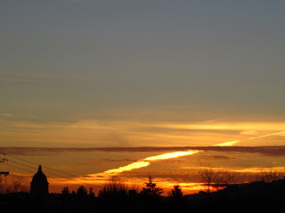
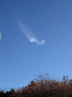
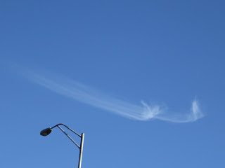
      The photo above and the two below are correctly sequenced and oriented thanks to some trees, bushes, what would otherwise be called an eyesore--a lampost.
   Because I was standing in the same place, I know that the cloud was moving west to east (right to left in the photos) and that the clumps were moving at a slower pace than the tails. Note that the tails get longer with each photo, indicating that they were trailing behind in slower, lower wind. This photo was hard to decipher because "behind" should be to the right, right? Yes, if the winds were blowing in a single direction throughout the troposphere. But they are not--and clouds are what show us they are not. I love this about clouds. They allow us to see the winds.
If you spend some time watching cirrus uncinus, you can watch the cloud age before your eyes. The ice-crystal tails will grow longer and longer with time and then dissipate altogether as the ice crystals evaporate. 

Lessons: When photographing clouds, don't zoom in so close that you can't figure out the relationship of the cloud to the earth. Always include a piece of landscape or even an unsightly structure you can crop out later. When photographing a single cloud, take several pictures a few minutes apart so you can see the subtle changes in the cloud's form.