Cloud of the Week #9 : Cumulonimbus

It's easy to see why Cumulonimbus are called the King of Clouds.
  Cloud lovers, this week we are going to tackle a progression of cloud forms in the cumulus genus. I think you are ready to observe some of the subtle differences that distinguish one type from the next. So let's start with a cloud that's been visiting our early spring landscape here in South Puget Sound--the cumulonimbus. This cloud is also known as the thunderstorm cloud or the "thunderhead." For those of you cloudspotters who are also wine lovers (me! me!), the cumulonimbus is the meteorological equivalent of a bold zinfandel, whereas our earlier delicate cirrus species are on par with a pinot noir.
   The bases of these convective clouds can extend from 2000 feet above the ground to 60,000 feet or so--which means their tops are reaching the tropopause (the boundary of the troposphere where it meets the stratosphere). In 1896, this cloud genus was classified as cloud nine in the International Cloud Atlas as it was the highest cloud (cloud one being the lowly stratus). Being "on cloud nine" came to describe a state of great elation among us land-bound humans. The expression still has currency today despite the little-known fact that subsequent reclassification pegs the cumulonimbus at Cloud Ten.
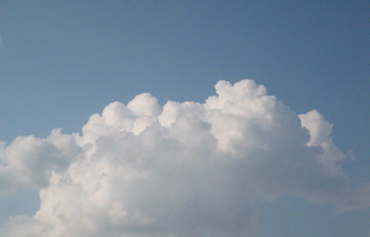
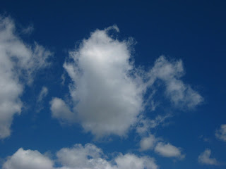
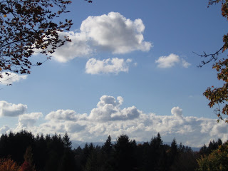
This is not a cumulonimbus cloud, it is a cumulus congestus. You can tell because it has the tight, cauliflower-like shape.
  
  You can watch a cumulonimbus form in a matter of minutes. Keep your eye on the rapidly rising clouds that seem to be churning out their outer edges--a cloud that resembles the one pictured above. This is a cumulus congestus cloud. It is composed of water droplets and due to the convection within the cloud, it is growing rapidly and rising toward the top of the troposphere. And, because pressure and temperature generally decrease with elevation/altitude, the water droplets in this cloud will start to freeze as they continue to rise. As the water droplets become ice crystals, the well-defined edges of the cloud soften. Now this cloud, pictured below,  is classsified as a cumulus calvus. Calvus means "bald," which will make more sense in a minute.
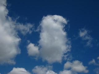
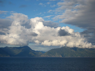
This is a cumulonimbus--a species called calvus. The cloud has lost its sharp edges.

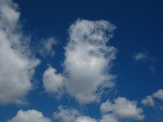
This is a cumulonimbus cloud--a type called capillatus. The lower "fringe" of this cloud is precipitation--rain or  hail.
 Now, our cloud is a full-fledged cumulonimbus capillatus as its top loses all definition as the ice-crystals increase and give the cloud a fibrous or wispy, hair-like appearance at its edges (in contrast to bald, or calvus). Capillatus means "hair like" in Latin. (Trick for remember this: capellini is angel hair pasta.).  Not only does our cloud get hairier, it flattens out as it reaches the upper boundary of the troposphere. This boundary, called the tropopause, limits the clouds growth. As our cloud flattens out, it becomes a tri-nomial: cumulonimbus capillatus incus. The word "incus" indicates is has the flat, anvil-shaped top.

This might be your view from beneath a cumulonimbus cloud.
   And because the clouds have been puring themselves down on us this past week, let's clear up nasty rumor about raindrops: they are not tear shaped. Small raindrops are actually spherical, like a ball.  This is because a sphere is the shape that requires the least amount of energy for the drop to hold itself together.


   As drops grow bigger than a millimeter or so, they start to become flat along their bottom edge as they fall, due to the resistance of air flowing around the drop. By the time a drop reaches 2-3 mm in diameter, it looks more like a hamburger bun than a sphere.  Drops bigger than about 6 mm in diameter are relatively rare because the air resistance tends to cause the drops to breakup as they fall.  
  And speaking of big raindrops, the largest one ever observed was 8.8 mm (possibly even 1 cm!). This Guinness Book of Record holders was measured by UW scientists Art Rangno and Peter Hobbs over the Amazon Basin and Marshall Islands in 2004.

Big, hamburger-bun-shaped raindrops require big umbrellas.


Cloud of the Week #8: Cumulus Fractus

 
   This week's cloud is a happy, low-level cloud called cumulus fractus--relatively small, ragged-edged clouds that seem more like mist than a cloud. The "fractus" part of its name is from the Latin for "part" or "fraction." These clouds typically form as detached cloud at 2,000-3,000 feet above the ground and are scattered across the sky in a somewhat haphazard fashion.
   Cumulus fractus form in two ways: They can form  in fair weather as rising pockets of warm air rise and condense into these proto-clouds that may develop into larger cumulus clouds with more defined "cauliflower" like edges. As cumulus fractus make their way across the sky, the moist air in them tends to evaporate in the surrounding dry air--so they don't stick around long. Below, you can see the deterioration of one cloud over just a few minutes.
This is a cumulus fractus cloud at its most compact stage.

Same cloud, seconds later, beginning to break up on the "top" side.

A few more seconds later it is really losing its form as it evaporates in the surrounding air. 
Cumulus fractus may "grow" into larger, more defined cumulus humilis clouds like these.
     You'll see cumulus fractus on not-so-fair days, too, as they "shedded" by larger cumulonimbus cloud after a rain storm (see dark cloud below).

   One of the essential qualities of clouds is that they are always in transition, always on their way to becoming something else, never holding the moment too tightly. Cumulus fractus clouds are a great way to start watching clouds because their you can witness their constantly changing forms as they hurry across they sky. More distant clouds, such as the cirrus "Clouds of the Week," actually move faster, but because of they are miles above us, their changes appear to be taking place more slowly and more subtly.

Cloud of the Week # 7: Altocumulus Undulatus?

   "The problem with clouds," my friend Jeff says, "is that their field marks are always different."
   For those birdwatchers, butterfly chasers, and wildlife viewers out there, you know the value of field marks in the identification of different species. You cannot simply say (as I do) "It's a marbled murrelet because I say it is," or "It just looks like one, besides, who else would be out here calling in the forest at 4 a.m.?" No, you must offer up some concrete details to support your pronouncement.
    Those details come in the form of field marks--the shape of the bill, the facial markings, the pattern plumage (or scales, fur, skin in the case of other animals). If you can say that the bird in your binoculars is a robin-sized bird sporting black wings, a black face and white collar, you can match this to the image in your field guide and feel confident  that you have identified a marbled murrelet and not a Xantus's, Kittlitz's, or Ancient murrelets bobbing on the water. If you are patient and methodical, you can probably identify the dozens of species of gulls whose field marks vary according not only to species but also to age, wear and fading of plumage, and stage of molt. If you are patient and methodical and equipped with a dozen field guides and charts, you still won't be able to pin down every cloud you see.
   Which brings me to this weeks cloud, altocumulus undulatus. At least, that's what I think it is. This is a mid-level cloud--I can tell this because there are other clouds--stratocumulus, nimbostratus, cumulus fractus-- that apear to be lower than/below them in my photographs. The clouds have a bit of puffiness to them, telling me they are altocumulus and not altostratus. And, as far as undulatus goes, this variety of cloud has elements (bands in this case) that are arranged in almost parallel lines or wave-like undulations created by wind action. This undulatus cloud resembles ripples, or undulations, made in the sand by the action of tide or ocean waves.  
   Still, I am not confident in my id because my two photographs match none of the photographs in my Weather Identification Handbook (by Storm Dunlop), or my Cloudspotter's Guide (by Gavin Pretor-Pinney) or The Audubon Society Field Guide to North American Weather, or the two editions of "A Guide to the Sky" poster (by Art Rangno). Nor do my clouds match any of the hundreds of photographs posted on the Cloud Appreciation Society's website. The field marks seem to have changed. Other ac undulatus are puffier, more extensive, more irregular, closer, whiter, photographed with better cameras!
  The four photographs below are also possible contenders for the altocumulus undulatus.
The clouds in the right corner look like the layered rippling, mid-level clouds.
These are altocumulus undulatus from above--a bit puffier, more extensive, and regular in undulations.

This altocumulus undulatus has very weird field marks. It's a "radiatus" type in an unusual stage of formation or deterioration thanks to cross winds aloft. 
This looks like a more mature version of the two altocumulus undulatus photographs at the top of this posting.
    See the problem? I am thinking that any field guide to the clouds, no matter how authoritative, is woefully misleading and makes Accidental Naturalists like me extremely (but happily) frustrated in their attempts to create tropospheric orderliness in a sky of chaos and mutability. Were I not 100% addicted to identifying the clouds I see, I would throw up my hands, pull out my lawn chair and just watch them and marvel at their infinite...yes, truly infinite...variety.
    There are some 370,000 different species of beetles, a fact that some like to joke, showed God had an "extraordinary fondness for beetles." Ha!


Cloud of the Week #6: Altostratus translucidis--boring?

Altostratus translucidis looking good at sunset behind the Washington State capitol dome.
  Now that we've moved a bit lower in the troposphere to the mid-level clouds (the fantastic new altocumulus asperatus cloud type!), I thought I would brighten up everyone's screen/life with some warm glowing sunsets courtesy of our Cloud of the Week #6--altostratus translucidis.  
  Though "alto" means "high," in meteorological circles it means "middle." So this Altostratus, typically forms at altitudes of 6,500 ft. to 23,000 feet. It assumes the basic form of a layer "stratus," and is therefore altostratus. There are four varieties of altostratus; this is the one that is thin enough (translucent) to show the position of the sun...even though it has just set.
Photo of altostratus sunset over Bellingham Bay, courtesy W.P Ruth
  Though you wouldn't know it from this photograph, altostratus is known among the cloud-spotting cognoscenti as the "boring cloud." In the middle of the day, these clouds do nothing photogenic or uplifting. They appear gray to bluish-gray and are often thick (thousands of feet thick) and extensive (several thousands of square miles).    Altostratus are composed of both ice crystals and water droplets and so diffuse light in a manner similar to ground glass. If you think you are looking up at altostratus, but see your shadow on the ground, you're probably looking at a higher, thinner could--cirrostratus.
    I guess I shouldn't have been surprised when I went rummaging through my files of cloud photographs and found none of altostratus by day. I have thousands of photographs of beautiful clouds, but now I will have to start collecting photographs of boring ones, too.
 

  Next Up:  The Accidental Naturalist reviews O'er the Land.