Why Clouds are White--Part 1.5

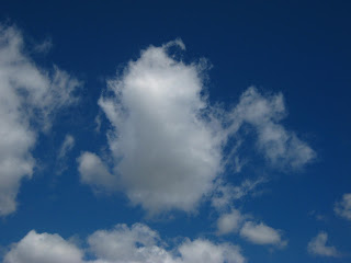
Still searching for an answer up here.
  Oh, I have been struggling this week to finish Part 2 of this post in which I sought to answer my own question: why are clouds white? I hate to disappoint my readers, but I have not been able to find a satisfactory explanation--one that really explains why.
   There are many explanations out there just as there are explanations for why the sky is blue. I nod at the answer to this one ("because air scatters blue wavelengths of light more efficiently than the other wavelengths in the visible spectrum"), but guess what? I don't really know what that means.
    Because I want to know what it means, I am now way down inside the water molecules that make up the clouds, inside the atoms of hydrogen and oxygen, riding the waves of the electromagnetic spectrum, to try to understand what happens to the electrons (if anything) when they are struck by sunlight.
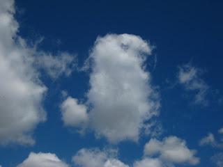
  This is getting me close to an answer, which is why this is Part 1.5. I am not quite there yet. Here is what I know: The reason clouds are white has to do with the relative sizes of the cloud droplet and the wavelengths of visible light. Which are both very very incredibly very tiny to us. To a cloud droplet and a wavelength, however, size does matter, though telling you that a cloud droplet is so large that is scatters all wavelengths equally (which is what I am being told) doesn't really explain the phenomenon of white clouds.
   So you are confident that The Accidental Naturalist is working diligently on the uber-story of the whiteness of clouds, I am reading a 1970 article from the Journal of Atmospheric Sciences (Volume 27) entitled "On the Possible Absorption of Visible Light by Clouds," by S. Twomy. It was the first article that showed up when I asked Google Almighty this question: Are individual wavelengths of visible light absorbed and emitted within the molecules of water within a cloud droplet or are they scattered without ever penetrating the droplet?
   Yes, 1970. That means I have some 41 years of articles to read to bring you the latest science on this very basic and possibly unanswerable question.
Here is a loaf of  bread I made on Sunday. It was delicious. When I get lost in the atmosphere, I like to come back down to earth in the kitchen. 
 

Fractus

  For those of you who enjoyed, were enlightened by, or read part of my previous blog How It Rains, I appreciate your dedicating a portion of your e-time to understanding this taken-for-granted atmospheric phenomenon. Sure, the Northern Lights are a much more spectacular-looking phenomenon, but I am not interested in sky bling right now. Drab, gray rain clouds are mind-bending enough.
   After I posted "How it Rains,"  I had quite a bit of clean up to do. I had markers, oil pastels, scraps of paper, pens, pencils, and other crafty things spread out all over my desk. I also had the remnants of the sponge I sacrificed in the name of science (above). The scraps (below) were too small to put to use in the kitchen, but I felt wasteful tossing them in the trash.
 So I decided to recycle them into my blog as an example of another cloud feature you should know about-- fractus. Fractus, as you can probably deduce, is from the same root as "fraction," meaning "part of." Cumulus fractus, therefore, are parts of cumulus clouds. Stratus fractus, parts of stratus clouds. These are the patches, misty bits, ragged edges, deteriorated fractions of larger clouds. You will see them floating by on their own or beneath a larger cloud mass. The free-floating ones are cumulus fractus and are often white.
The shreddy bits of white cloud are cumulus fractus.
 
 Unless the light is fading and they appear pink (below).
 Cumulus fractus in upper half of photo.        Photograph by M. Ruth
  Or gray after the sun has set (below).
    Gray Cumulus fractus just above trees.                       Photo by M. Ruth
   You might also see stratus fractus; these are gray.

If you see very dark gray stratus fractus beneath a nimbostratus cloud, they are called pannus (below).

Cloud of the Week #8: Cumulus Fractus

 
   This week's cloud is a happy, low-level cloud called cumulus fractus--relatively small, ragged-edged clouds that seem more like mist than a cloud. The "fractus" part of its name is from the Latin for "part" or "fraction." These clouds typically form as detached cloud at 2,000-3,000 feet above the ground and are scattered across the sky in a somewhat haphazard fashion.
   Cumulus fractus form in two ways: They can form  in fair weather as rising pockets of warm air rise and condense into these proto-clouds that may develop into larger cumulus clouds with more defined "cauliflower" like edges. As cumulus fractus make their way across the sky, the moist air in them tends to evaporate in the surrounding dry air--so they don't stick around long. Below, you can see the deterioration of one cloud over just a few minutes.
This is a cumulus fractus cloud at its most compact stage.

Same cloud, seconds later, beginning to break up on the "top" side.

A few more seconds later it is really losing its form as it evaporates in the surrounding air. 
Cumulus fractus may "grow" into larger, more defined cumulus humilis clouds like these.
     You'll see cumulus fractus on not-so-fair days, too, as they "shedded" by larger cumulonimbus cloud after a rain storm (see dark cloud below).

   One of the essential qualities of clouds is that they are always in transition, always on their way to becoming something else, never holding the moment too tightly. Cumulus fractus clouds are a great way to start watching clouds because their you can witness their constantly changing forms as they hurry across they sky. More distant clouds, such as the cirrus "Clouds of the Week," actually move faster, but because of they are miles above us, their changes appear to be taking place more slowly and more subtly.