T. Rex of the Sky

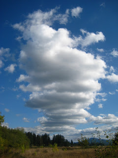
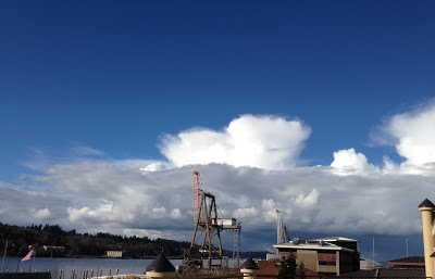
Cumulonimbus clouds rising over Puget Sound.   Photo courtesy M. D. Ruth

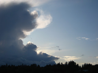
      It was hard to miss these towering clouds if you were out and about anywhere in Puget Sound today. These are culumonimbus clouds--the tallest of the clouds--showing its flattened anvil shape at its icy top. Because of the anvil shape, these clouds are more precisely described as cumulonimbus incus. If you watched long enough you might have seen the tops spread out in wisps, or hairs--turning them into cumulonimbus incus capillatus--and you into a Latin scholar! Incus means anvil; capillatus means hai-like.
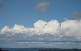
  These clouds are composed of water droplets in their lower portions and ice crystals in their upper portions. This was a cumulus congestus cloud (the big, cauliflower shaped ones) earlier in the day and rose through the troposphere under its own power --power produced within it as water molecules in the cloud condensed into droplets and released a tiny amount of heat (called latent heat). The cumulus congestus  continues to build until it reaches the troposphere/stratosphere boundary, called the tropopause, beyond which the air temperature begins to increase with altitude. When the cumulus congestus cloud hits this boundary, it can no longer rise, so it flattens out and assumes its distinctive anvil shape and its status as a cumulonimbus.
   Though cumulonimbus clouds are considered "low" clouds because their bases are low--just 2000 feet above the earth's surface. These majestic clouds are the tallest of the clouds, rising up to 40,000 feet above the earth.
   As you may remember, "nimbus" implies rain. And though Olympia was dry while this cloud was putting on its show this afternoon--some places to the northwest were getting hammered. With rain, maybe hail. Maybe drinks, too--but that's mixology, not meteorology.
  Cheers to the Clouds!

Mammatus Clouds

 
Saturday's mammatus clouds posted on KIRO TV
       A local cloudwatcher asked if I had these unusual clouds on my list. They are very strange, often eerie, mammatus clouds, and were featured on KIRO-TV's website Sunday after they made appearance over Seattle on Saturday when our weather did a swift, tumultuous, seasonable 180. It was summer on Friday, fall on Monday.
    Unfortunately, KIRO 7 Meteorologist Morgan Palmer explains them this way: 
"It's a pocket of mammatus, forming because it looks like a small deformation axis, or area has developed. That's where the typically laminar air flow is being interrupted or 'held up' as air is moving through. This is causing billowing as the air stream is buckling a bit. It probably resulted from a combination of topographic effects and the increasing instability late Saturday. Air pockets were bouncing up and down all over the place ahead of the front."
   I have no idea what this means. The Accidental Naturalist is here to help you out. Here is my understanding of how mammatus clouds are formed.*
     The clouds, named mammatus (Latin for "having breasts") resemble strange udders. Mammatus do not form in isolation, but are what is called a supplementary feature of other clouds. Mammatus "hang" from the underside cumulonimbus clouds. How did they get there?
   As you may recall, clouds are formed as warm air rises and the molecules of invisible water vapor condense and become liquid droplets. This change in phase--from vapor to liquid--releases hidden (latent) heat into the surrounding atmosphere. This warms the air gives the molecule a tiny lift.
   Our water molecule now comes to a fork in the sky: evaporate back into water vapor or join with other water molecules. Our molecule takes the fork toward Joinersville. If a billion(ish) water molecules take this fork, they eventually grow to the size of a water droplet. Multiply that by a number too obscenely large for this family friendly blog and, under the right atmospheric conditions, the water droplets develop into a cloud. 
   You probably knew where this was going, eh?
    Now, let's say our cloud stays the course, and more and more water droplets form and we get a cumulus humilis cloud (below)--the youngest and humblest of the cumulus clan. 
A stack of cumulus humilis--wider than they are tall.
    The cumulus humilis continues to grow as more and more water vapor condenses, the latent heat from the condensation keeps the cloud rising, as it rises into cooler and cooler air, the rate of condensation increases. And the amount of released heat increases within the cloud. Our cumulus humilis becomes a larger cumulus mediocris (was unavailable for photo at posting time), then even larger cumulus congestus (below). Now there is strong genuine updraft within the cloud.
Cumulus congestus--cauliflower-like tops.
Now it seems to take on a life of its own. The water droplets grow to the size of rain droplets, the release of latent heat sustains the convection, and our billowy cloud rises to the tropopause--the boundary of the troposphere and the stratosphere--where the top of the cloud flattens out. Now we have a cumulonimbus with an icy incus (Latin for "anvil") at the top (below).
A cumulonimbus with incus.
 Don't worry, I haven't forgotten about the breasts.

     As you can imagine, great updrafts are created within a cumulonimbus cloud. These updrafts can transport large quantities of rain-dense air rapidly from the base of the cloud toward the top. At the top, they become ice crystals. If the ice crystals come into contact with the dry air above them, they evaporate without first melting into water. This process is called sublimation
   Recall that condensation of water vapor releases heat into the atmosphere. Sublimation does the opposite: it absorbs heat from the atmosphere around it. This chills local areas in the cloud. The cooler air becomes more dense and then sinks through the bottom of the anvil. When this air reaches warmer air, it condenses and appears as these eerie, pouchy, mammatus. They are typically 1-3 km in size. Their life span is about 10 minutes. 
    Mammatus are rare. They form when cold air sinks into warm air. This is exactly the opposite/upside-down of how convective clouds form--warm air rising into cold air.
   Mammatus are rarely photographed. Predictive models have yet to be developed. Observations are serendipitous. You'll increase your chances of seeing these if you look up.  
   I hope this has been helpful. If not, here's something to contemplate:  
  The mermaid (above) is the personification of a cumulonimbus cloud with supplementary incus and mammatus. Her body being the cumulonimbus, her arms being the flattened incus, and, well...you can figure out the rest.
 
* Shortly after the Accidental Naturalist finished a draft of this blog, she discovered a scientific article in the Journal of Atmospheric Sciences titled "The Mysteries of Mammatus Clouds: Observations and Formation Mechanisms." She got a sinking feeling when she saw the word "mystery" and read the list of possible ways they are formed:

  "...anvil subsidence, subcloud evaporation/sublimation, melting, hydrometeor fallout, cloud-base detrainment instability, radiative effects, gravity waves, Kelvin–Helmholtz instability, Rayleigh–Taylor instability, and Rayleigh–Bénard-like convection."
   Click here to read the article...or just to ogle the great photos of mammatus clouds.


Leave Me Behind...Please!

Rapture Cloud or just plain ol' Cumulonimbus? Photo taken at 8:14 p.m. in Washington, DC, by an alert cloudspotter who will likely be in heaven three hours ahead of me accounting for the time difference and all. 

  As some of you may know, Saturday--May 21, 2011, is rumored to be Judgement Day, the day of Rapture that precedes the End of the World which is scheduled for October 21 (I am not sure exactly what time). But don't take my word for it, there are plenty of web sites with proof, many using big scary clouds like this one enhance the "truthiness" of the claims.
  Me? I am just going to relax and enjoy our Pacific Northwest blue skies tomorrow. I hope you do the same. But, if you're worried about anything happening in the next six months or so, take comfort in the fact that there are plenty of "Left Behind" services being offered by entrepreneurs. You can find out which services--and pay for them in advance on the Internet. Think about it! Who is going to feed your dog?
  

Cloud of the Week #9 : Cumulonimbus

It's easy to see why Cumulonimbus are called the King of Clouds.
  Cloud lovers, this week we are going to tackle a progression of cloud forms in the cumulus genus. I think you are ready to observe some of the subtle differences that distinguish one type from the next. So let's start with a cloud that's been visiting our early spring landscape here in South Puget Sound--the cumulonimbus. This cloud is also known as the thunderstorm cloud or the "thunderhead." For those of you cloudspotters who are also wine lovers (me! me!), the cumulonimbus is the meteorological equivalent of a bold zinfandel, whereas our earlier delicate cirrus species are on par with a pinot noir.
   The bases of these convective clouds can extend from 2000 feet above the ground to 60,000 feet or so--which means their tops are reaching the tropopause (the boundary of the troposphere where it meets the stratosphere). In 1896, this cloud genus was classified as cloud nine in the International Cloud Atlas as it was the highest cloud (cloud one being the lowly stratus). Being "on cloud nine" came to describe a state of great elation among us land-bound humans. The expression still has currency today despite the little-known fact that subsequent reclassification pegs the cumulonimbus at Cloud Ten.
This is not a cumulonimbus cloud, it is a cumulus congestus. You can tell because it has the tight, cauliflower-like shape.
  
  You can watch a cumulonimbus form in a matter of minutes. Keep your eye on the rapidly rising clouds that seem to be churning out their outer edges--a cloud that resembles the one pictured above. This is a cumulus congestus cloud. It is composed of water droplets and due to the convection within the cloud, it is growing rapidly and rising toward the top of the troposphere. And, because pressure and temperature generally decrease with elevation/altitude, the water droplets in this cloud will start to freeze as they continue to rise. As the water droplets become ice crystals, the well-defined edges of the cloud soften. Now this cloud, pictured below,  is classsified as a cumulus calvus. Calvus means "bald," which will make more sense in a minute.
This is a cumulonimbus--a species called calvus. The cloud has lost its sharp edges.

This is a cumulonimbus cloud--a type called capillatus. The lower "fringe" of this cloud is precipitation--rain or  hail.
 Now, our cloud is a full-fledged cumulonimbus capillatus as its top loses all definition as the ice-crystals increase and give the cloud a fibrous or wispy, hair-like appearance at its edges (in contrast to bald, or calvus). Capillatus means "hair like" in Latin. (Trick for remember this: capellini is angel hair pasta.).  Not only does our cloud get hairier, it flattens out as it reaches the upper boundary of the troposphere. This boundary, called the tropopause, limits the clouds growth. As our cloud flattens out, it becomes a tri-nomial: cumulonimbus capillatus incus. The word "incus" indicates is has the flat, anvil-shaped top.

This might be your view from beneath a cumulonimbus cloud.
   And because the clouds have been puring themselves down on us this past week, let's clear up nasty rumor about raindrops: they are not tear shaped. Small raindrops are actually spherical, like a ball.  This is because a sphere is the shape that requires the least amount of energy for the drop to hold itself together.


   As drops grow bigger than a millimeter or so, they start to become flat along their bottom edge as they fall, due to the resistance of air flowing around the drop. By the time a drop reaches 2-3 mm in diameter, it looks more like a hamburger bun than a sphere.  Drops bigger than about 6 mm in diameter are relatively rare because the air resistance tends to cause the drops to breakup as they fall.  
  And speaking of big raindrops, the largest one ever observed was 8.8 mm (possibly even 1 cm!). This Guinness Book of Record holders was measured by UW scientists Art Rangno and Peter Hobbs over the Amazon Basin and Marshall Islands in 2004.

Big, hamburger-bun-shaped raindrops require big umbrellas.