Warm Sun, Icy Skies, Bittern

Cirrus duplicatus over Enumclaw, Washington
  Our recent and most-welcome warm weather in Western Washington this week has brought warm temperatures (50s F) and cloudy skies to the region. Cloudy?! locals might gasp. Yes, cloudy, the Accidental Naturalist insists. I'm on a mission to restore the good name of "cloudy" and divorce it from its knee-jerk association with low, gray, rain-making clouds. This weekend was cloudy. Just look.
   Saturday, my husband and I drove toward Enumclaw for a snow-free, low-elevation hike along the White River. With the dog. Who needed a leg-stretch. Who got us out on a rails-to-trails path outside the town of Buckley. Where we watched the skies get crazy with cirrus clouds that first caught my husband's eye because they looked "square."
   Nature isn't too fond of square shapes, especially in the cloud department, but these clouds had some edges and corners (at least from our perspective):
"Square" clouds indicate cirrus at more than one altitude with winds blowing the filaments in different directions.
  Once we started looking up at these clouds, we couldn't stop looking. Then the breeze kicked up. We walked a bit further, looking east, west, north, and south toward Mt. Rainier. We couldn't figure out what the skies were telling us. So I told my husband I thought the sky was "thickening" a bit and it would likely rain in 24 hours. Maybe 36. This was a mistake. I figured I had a 70-30 chance of being right. It was, after all, February in the Pacific Northwest. Often, cirrus clouds to portend rain. But only if they show a marked progression of lowering (to cirrostratus, altostratus, nimbostratus...rain). These cirrus dominated the sky.
I'm not sure what's going on here with this leaping cirrus cloud.
Here we have cirrus fibratus (I'm 86% sure) and what appears to be a salmonid migration of small altocumulus lenticularis.
  I have about fifty photographs of the skies on Saturday. I will spare you only so I have your attention for what happened on Sunday--another cloudy day in South Puget Sound. Look!
Clouds at sunset at Nisqually NWR. During the Super Bowl.  It is challenging to tell cirrocumulus from altocumulus--I haven't acquired the skill yet to judge the size of the cloudlets or height of the clouds. I'm working on it.
Heading west on the I-5 toward the Black Hills, the clouds produced a feature that looked like whale's baleen.  I believe these are trailing ice-crystals called virga. 
  At this point, you might be wondering why I seem to know so little about the clouds I saw this weekend. The problem is that despite my studying, constant use of cloud guides, sky guides, weather blogs, and National Weather Service data, it's difficult to match the clouds I'm seeing at any one moment to the data available. And no matter how many photographs I scrutinize, the clouds in the pictures (the supposed "type specimen") never quite match the pictures I've taken. Unlike the American Bittern.
An American Bittern, one of four seen hunting during the Super Bowl at Nisqually National Wildlife Refuge.
  Under those gorgeous sunset skies at Nisqually on Sunday, my husband and I were able to identify the secretive and camouflaged marsh bird--the American Bittern. This relative of the herons was hunting in the reeds and grass along one of the inner boardwalks. It looked just like its photograph in the Audubon field guide. We walked a bit further. And we saw four more bitterns. They looked and acted like the field guides said they would. It was so simple. And so satisfying.


Cloud of the Week # 4: Cirrus uncinus


  Some of you may remember this cloud from an earlier "Accidental Naturalist" blog posting. This solitary cloud is an unusual form of a type of cirrus cloud called cirrus uncinus. 'Uncinus' (pronounced un-sun-us) means that the streaks falling behind the main clump of ice crystals are in the shape of hooks or commas. A common type of cirrus uncinus, one familiar to many people, are the 'mare's tails,' which, as you might expect, look like a horse's tail (mare or stallion, or even pony if you ask me).
   Unfortunately, I don't have any photographs of mare's tails and because I am trying to behave on the Internet, have chosen not to cut and paste someone else's photo in here. But here is a link.
  Not describing someone else's photo turned out to be a good thing for many reasons. It took me almost an hour (!) to select the three photographs posted here. Why? Because I am in the habit of turning my camera sideways to capture a scene vertically and I often forget to include a piece of landscape in the photograph. This is a problem when I want to post a sequence of photos to show the progression of a cloud over several minutes. I had posted some very wonderful cirrus uncinus, but had to delete them when I couldn't be sure I had the orientation and chronology correct. After I checked the time stamp on the images, I fixed the chronology problem, but then couldn't be sure up was up and down was down. One of my cirrus uncinus seemed to be doing cartwheels.
      The photo above and the two below are correctly sequenced and oriented thanks to some trees, bushes, what would otherwise be called an eyesore--a lampost.
   Because I was standing in the same place, I know that the cloud was moving west to east (right to left in the photos) and that the clumps were moving at a slower pace than the tails. Note that the tails get longer with each photo, indicating that they were trailing behind in slower, lower wind. This photo was hard to decipher because "behind" should be to the right, right? Yes, if the winds were blowing in a single direction throughout the troposphere. But they are not--and clouds are what show us they are not. I love this about clouds. They allow us to see the winds.
If you spend some time watching cirrus uncinus, you can watch the cloud age before your eyes. The ice-crystal tails will grow longer and longer with time and then dissipate altogether as the ice crystals evaporate. 

Lessons: When photographing clouds, don't zoom in so close that you can't figure out the relationship of the cloud to the earth. Always include a piece of landscape or even an unsightly structure you can crop out later. When photographing a single cloud, take several pictures a few minutes apart so you can see the subtle changes in the cloud's form.

Cloud of the Week #2: Cirrus vertebratus

Cirrus vertebratus           (photo by M. Ruth)
  May I present the Cloud for the (mid)Week. This is cirrus vertebratus, a type of cirrus cloud resembling a spinal column or fish skeleton, hence the Latin vertebratus for vertebrae-like. Like other cirrus clouds, this forms high in the atmosphere, usually starting out as a smooth band of ice crystals that is then blown by crosswinds to create the fine filaments or streaks to either side of the "column." This cloud, remarkably, features a spine attached to a cloud that resembles hip bones! FYI: I did not PhotoShop this image.
  These high clouds form at the same altitude as last week's cirrus radiatus--16,500-45,000 ft.--and usually indicate otherwise clear skies. They may however, thicken and begin a progression toward deteriorating weather.
  Many of you took my "Head in the Clouds Survey" last month and identified the jet contrails in one photograph as cirrus clouds. I should have given you half credit for this answer, because contrails and cirrus clouds both form at similar altitudes and do look alike sometimes . I guess you could call a contrail a faux cirrus or psuedo cirrus (which is more fun to say out loud).  Below is a photo of a jet contrail mimicking a cirrus vertebratus.

Jet contrail mimicking cirrus vertebratus   (photo by M. Ruth)

  In fact, this looks more like human vertebrae than the top photo. How do I know this is a jet contrail? Because I was watching the sky to the south of my home where I usually see jet contrails (heading north from Portland). I watched and photographed the deterioration of the contrail so I know this was not a naturally formed cirrus vertebratus. If such contrails formed amid authentic cirrus vertebratus, the identification would be trickier.
   Real Ci ve (the official code) materialize in the sky gradually, almost imperceptibly, are irregular in width, and do not have a plane at one end (!) Jet contrails usually appear in the same sector of the sky (relative to your nearest airport), usually follow similar flight paths (mostly parallel, but with some criss-crossing), and are similar in width.   
  Though I have taken thousands of photographs of clouds in the past year, I would like to lure my readers to other websites where you can see thousands more. Click here to go to Clouds Online, a fabulous easy-to-navigate cloud atlas.
 
Next up:  Tangled Cirrus

Ice Comet?

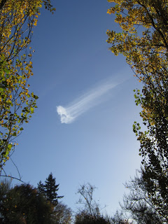
 Last Tuesday, November 2, I stopped by the City of Olympia Public Works complex to return the Zero Waste Event containers I had borrowed and, because there is a pocket park at the edge of the parking lot where I pulled in, decided to stroll through the park, whip out my cell phone, and call my mom on the East Coast.  Luckily, she was in the mood for a good chin wag, so the call went on for quite a while. Thanks to Washington State's new cell phone laws, I could not get back in my car and drive home while talking, so I just kept strolling around the park among the dwarfish statues of construction workers set among the picnic tables.
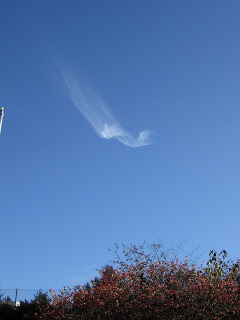
  And, while I was strolling and chatting and admiring the gorgeous blue sky and fall foliage, a lone cloud appeared (above) to the south at 3:38 p.m. It was a cirrus cloud impersonating a comet--a very slow comet that seemed to not actually be moving. But I kept watching. And watching. And chatting, listening, strolling, and taking pictures of what was happening: as the tufts of this cloud moved across the sky 
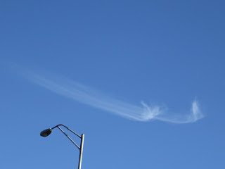
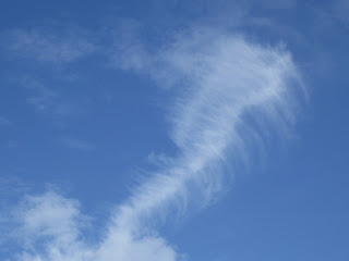
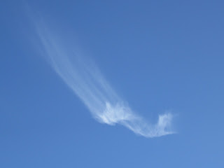
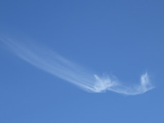
apparently from west to east, the tail, called a fallstreak, changed its orientation to the tufts--from the 2 o'clock position in the photo at top, counterclockwise to the 11 o'clock position in the photo below, and then  to 10 o'clock in the bottom photo.

   It's easy to stroll, and chat, snap a few photos, post them here, and say "cool clouds!" It's much harder to explain exactly what was happening.  I studied this photo sequence and other cirrus clouds from my field guides to try to tell the story here. Here is what I know: Cirrus are the highest clouds, forming most often at altitudes of 16,500-45,000 feet. They are composed of ice crystals. They will form in a clear sky, as they did here. As I understand them, the ice crystals that form in the fast high winds descend into slower, warmer air and lag behind the "front" tuft of the cloud. If the fallstreaks descend through drier/warmer air, they evaporate and decay. If they descend through moister/cooler air, the crystals grow and the streak expands.
   The more I looked at my photos and recalled the movements of the tufts and the streaks, the dizzier I got trying to understand which way was up. From where I was standing near the dwarf with a manhole cover perched jauntily on his yellow hardhat, it appeared that the tuft was moving west to east (right to left in this photo) and that the streaks were moving counterclockwise around the tufts. But I am not sure. The streaks do not look like they are falling--but rising on some invisible current of air.
  I went to the Cloud Appreciation Society Cloud Appreciation Society and looked through 719 photographs of cirrus clouds. All were spectacular, none matched my photos.
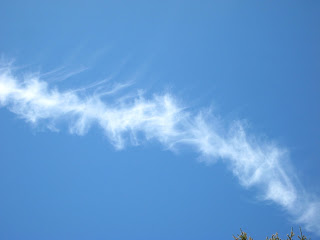
   And then I search for images on the Internet. Part way through the 4,160 photos, I came across a cloud that was close to mine on WeatherOnline (below). It captured the spirit of my cloud, but not its singularity,elegance, or cometesque-ness.

    Was my cloud unique or was my perspective "off" somehow? I needed help from my friends at the Cloud Appreciation Society.  Stayed tuned (as we used to say and some still do) for an explanation.