The Problem with Clouds...


   ...is that there are no type specimens or field markings to positively identify them. There are basic guidelines for identification--the general shape, altitude, and opacity of the cloud--but only sometimes does a description or photograph of a cloud in a field guide really match the cloud you are studying in the real world.
   Take the photograph above, for instance, taken by my niece in Washington, DC. Judging by their layered, clumpy form, shading, and estimated altitude (low), these beautiful clouds are, I believe, stratocumulus perlucidus clouds. Stratocumulus are one of my favorite types as they usually move with some urgency across the sky almost like a time-lapse video. And we have plenty of them here in the Pacific Northwest. Here are some other examples of stratocumulus perlucidus clouds.


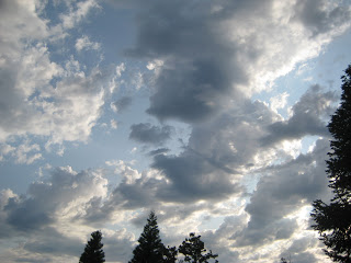
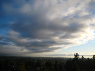
  You can see that they are all generally similar--low clouds which, according to Michael Allaby's Encyclopedia of Weather and Climate, appear in "patches, sheets, or layers of gray, white, or both gray and white cloud. There are always dark areas, shaped as rolls or rounded masses. These sometimes merge into larger masses."
   But stratocumulus always seem to be changing from or to another type of cloud such as stratus, cumulus, or altocumulus, so you'll see characteristics of these clouds in the stratocumulus. That makes them hard to i.d. But that is part of their charm. Just go with "stratocumulus-ish" or "stratocumulus-esque" and you'll be fine...ish.
   

Archaic and Passe? Dang.


   Well, Cloud of the Week fans, I've suffered a major set back. Shortly after visiting the University of Washington library to see the 1939 edition of the Atlas International des Nuages (International Cloud Atlas, I wrote to my favorite cloudman to tell him I was planning a trip to see the 1896 edition of this atlas at the Library of Congress in Washington, DC. He was, he wrote back, envious. And he admired my persistence in tracking down these early editions.
   He himself had written a piece on cloud classification years ago but, he admitted, he didn't consult this atlas--the "bible" of cloud classification published by the World Meteorological Organization. "Frankly, he wrote, "the ID-ing for clouds has become a bit passe." Ouch! "I think it's seen as archaic now." Double ouch.
   Just as I was feeling comfortable pointing to the sky and saying "Look! A cumulus congestus capillatus!" Just as I was ready to post another Cloud of the Week (after a weeks off) here. Just after I had laminated a two-page cloud key for my personal enrichment in the great outs of door.
   Tossing aside cloud identification, he suggested beginning students of meteorology focus on learning just a few things: 1) Being able to tell ice clouds from droplet clouds, 2) recognizing the signs of an advancing storm, and, 3)  because we are in Puget Sound, recognizing the Convergence Zone. This can be accomplished without books, laminated keys, or blogs--just "by eyeballing and nothing more."
Ice clouds.
This is a way more practical approach to the clouds. It is, however, an approach from a Real Scientist interested in weather and not an Accidental Naturalist with quirky passion for archaic Latin nomenclature, the poetry of clouds, and old atlases published in French.
"Nuages isoles, delicats, a texture fibreuse,
sans ombres propres, generalment de
couleur blanche, souvent d'un eclat soyeux."
  Fortunately, there is room for both on my blog and in my book. So, I will post more Clouds of the Week and will begin to tackle the three essentials listed above. I would hate you to feel outmoded by what you learn here.