
 |
| Saturday's mammatus clouds posted on KIRO TV |
Unfortunately, KIRO 7 Meteorologist Morgan Palmer explains them this way:
"It's a pocket of mammatus, forming because it looks like a small deformation axis, or area has developed. That's where the typically laminar air flow is being interrupted or 'held up' as air is moving through. This is causing billowing as the air stream is buckling a bit. It probably resulted from a combination of topographic effects and the increasing instability late Saturday. Air pockets were bouncing up and down all over the place ahead of the front."I have no idea what this means. The Accidental Naturalist is here to help you out. Here is my understanding of how mammatus clouds are formed.*
The clouds, named mammatus (Latin for "having breasts") resemble strange udders. Mammatus do not form in isolation, but are what is called a supplementary feature of other clouds. Mammatus "hang" from the underside cumulonimbus clouds. How did they get there?
As you may recall, clouds are formed as warm air rises and the molecules of invisible water vapor condense and become liquid droplets. This change in phase--from vapor to liquid--releases hidden (latent) heat into the surrounding atmosphere. This warms the air gives the molecule a tiny lift.
Our water molecule now comes to a fork in the sky: evaporate back into water vapor or join with other water molecules. Our molecule takes the fork toward Joinersville. If a billion(ish) water molecules take this fork, they eventually grow to the size of a water droplet. Multiply that by a number too obscenely large for this family friendly blog and, under the right atmospheric conditions, the water droplets develop into a cloud.
You probably knew where this was going, eh?
Now, let's say our cloud stays the course, and more and more water droplets form and we get a cumulus humilis cloud (below)--the youngest and humblest of the cumulus clan.
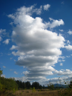 |
| A stack of cumulus humilis--wider than they are tall. |
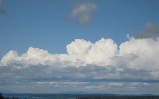 |
| Cumulus congestus--cauliflower-like tops. |
Now it seems to take on a life of its own. The water droplets grow to the size of rain droplets, the release of latent heat sustains the convection, and our billowy cloud rises to the tropopause--the boundary of the troposphere and the stratosphere--where the top of the cloud flattens out. Now we have a cumulonimbus with an icy incus (Latin for "anvil") at the top (below).
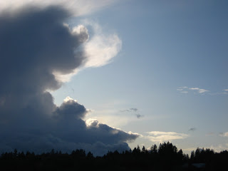 |
| A cumulonimbus with incus. |
Don't worry, I haven't forgotten about the breasts.
 |
Recall that condensation of water vapor releases heat into the atmosphere. Sublimation does the opposite: it absorbs heat from the atmosphere around it. This chills local areas in the cloud. The cooler air becomes more dense and then sinks through the bottom of the anvil. When this air reaches warmer air, it condenses and appears as these eerie, pouchy, mammatus. They are typically 1-3 km in size. Their life span is about 10 minutes.
Mammatus are rare. They form when cold air sinks into warm air. This is exactly the opposite/upside-down of how convective clouds form--warm air rising into cold air.
Mammatus are rarely photographed. Predictive models have yet to be developed. Observations are serendipitous. You'll increase your chances of seeing these if you look up. I hope this has been helpful. If not, here's something to contemplate:
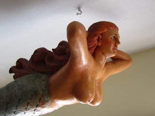
The mermaid (above) is the personification of a cumulonimbus cloud with supplementary incus and mammatus. Her body being the cumulonimbus, her arms being the flattened incus, and, well...you can figure out the rest.
* Shortly after the Accidental Naturalist finished a draft of this blog, she discovered a scientific article in the Journal of Atmospheric Sciences titled "The Mysteries of Mammatus Clouds: Observations and Formation Mechanisms." She got a sinking feeling when she saw the word "mystery" and read the list of possible ways they are formed:
"...anvil subsidence, subcloud evaporation/sublimation, melting, hydrometeor fallout, cloud-base detrainment instability, radiative effects, gravity waves, Kelvin–Helmholtz instability, Rayleigh–Taylor instability, and Rayleigh–Bénard-like convection."Click here to read the article...or just to ogle the great photos of mammatus clouds.