 |
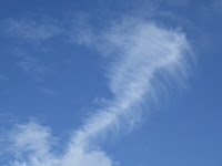
| Cirrus intortus with some cumulus trying to get in the picture. |
We are still in the upper layer of the troposphere, roughly five to eight miles above the earth, where the cirrus clouds are formed. This variety of cirrus is known as cirrus intortus.
If you know even the tiniest bit of Latin, you will guess that "intortus" is related to tortuous, torture, contort and is from the Latin tort, meaning twisted. These are cirrus whose fallstreaks of ice crystals have been twisted by the winds of different speeds and directions as they fall. The particular pattern of the twist is also influenced by the varying temperatures and humidities the ice crystals encounter on their way down.
If your Latin fails you when you are cloudwatching and you see thin, wispy clouds that look like tangled hair, you're looking at cirrus intortus.
 |
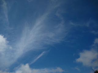
| Cirrus intortus with a few jet contrails in the mix. |
Don't imagine that the presence of these clouds means "twisters" on the ground. Cirrus respond to very high winds in the atmosphere that do not correspond to ground-level winds. What I love about cirrus is that they are the winds made visible. The winds are likely blowing around on blue-sky days, too, but we can't see or feel them.
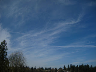
Though it would make my job of reading the clouds simpler, the skies seldom feature just one variety or species of cloud at a time. In the photo below, you can (I hope) spot the cirrus intortus clouds and some other clouds that look thicker, milkier and something that looks like a rainbow. What you are seeing is another type of cloud--cirrostratus (ice crystals in a thick layer) and a halo. Like a rainbow, the halo is produced when the sun strikes the water in the sky a certain way. Sunlight striking water droplets just so creates rainbows; sunlight that strikes ice crystals just so produces a halo. The halo can appear as a complete or broken ring. 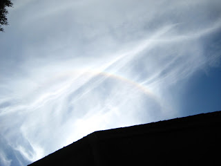 |
| Cirrus intortus, cirrostratus, and a 22-degree halo. And a silhouetted roof. |
Now, we have learned three types of cirrus so far this year. See if you can name the first two (below). Give yourself a pat on the back if can. Go back to my earlier blogs if you can't. Remember, it's okay to just call 'em "cirrus" or the "high, icy ones." Just keep looking up.