Lake Ozette sprawls across the remote northwest corner of Washington just a mile from the Pacific Ocean. The lake was named for the village of Ozette, a now-abandoned whaling village occupied from 440 BC to 1750 AD by the Makah peoples. Lake Ozette’s waters, shoreline, and buffering forest fall entirely within Olympic National Park.
In terms of superlatives, Lake Ozette ranks as one of Washington’s top three largest natural, undammed lakes. Establishing the exact ranking is a challenge. Lake Washington is often cited as the first orsecond largest undammed lake and Lake Chelan still gets listed as second largest despite the fact that it was dammed in 1927.
No matter, Lake Ozette is immense as an ocean to a wild swimmer. This wild and undeveloped lake is about nine miles long and averages two miles across (for a total of 12 sq. mi) and is 331 feet deep at its deepest point. It shoreline and bathymetric contour lines are convoluted.

The convoluted shoreline of Lake Ozette makes it a great place to explore by canoe—plenty of bays, coves, points, nooks, crannies, and few uninhabited islands.
The lake’s shoreline is undeveloped. There is a ranger station, campsites, parking lot, restrooms, and boat launch at the north end of the lake and a boat ramp on the eastern shore. Most visitors to Lake Ozette do not come to swim or even boat on the lake, but to hike the ~3-mile mostly board-walked trails to the Pacific Coast at Sand Point or Cape Alava, or hike the “Ozette Triangle,” which includes these trails and (tide willing) the stretch of beach between then camp along the coast. I was there to swim.
There are no designated swimming beaches on Lake Ozette. In fact, there is no information at all at the ranger station or in my guide books about swimming in the lake. I have discovered that our state’s lakes are underswum; they merely give their names to trails, provide a scenic destination for a picnic, or offer a place to fish. Swimming is rarely, if ever, mentioned as a possibility. Which is a shame. For me, there is no better trail’s-end reward than a refreshing swim.
Given its size, remoteness, and proximity to the ocean, I have always thought of Lake Ozette as intimidating though I had never visited to find out for myself. To discover the best swimming spot and also to swim safely, my husband and I set aside two days in late June to explore the lake in our Penobscot 16 canoe and camp at Erickson’s Bay on the lake’s west shore. The weather was warm, the air calm, and I had my wetsuit and had been lake swimming since March. I was as ready as I’d ever be.
We launched our canoe at Ozette and paddled south on lightly choppy water for four miles toward Erickson’s Bay. We had the entire lake to ourselves, minus a family of mergansers.
Despite the fact that Erickson’s Bay is a boat-in-only campsite, I was expecting the place to be swarming with boats and campers who had arrived ahead of us. Much of the Olympic National Park has been designated the Daniel J. Evans Wilderness and to reduce the human impact in these areas, there is now a permitting systemin place for overnight camping. Along the coast west of Lake Ozette are limited to just a few sites; Erickson’s Bay was listed as having “99+” sites—in other words, it was a large site with a virtually unlimited number of permits.
As we paddled toward the shore of the bay, we did not see a single canoe, kayaked, or anchored motor boat. We did not see a single sign marking the way to the camping area. The only indication that we were on target was a break in the shoreline salad hedge and a trail leading to a beautiful driftwood bench.

The only sign that you’ve arrived at the entrance to the primitive campground at Erickson’s Bay on Lake Ozette is this alluring driftwood bench. Photo by MM Ruth.
Civilization! We beached the canoe and walked up the trail. Not only was there the bench, there was a stone fire ring and a smooth flat spot for our tent. And a nearby privy. Before committing to this perfect bay-view site, we strolled through the forest and discovered not a single human soul, but a very tidy forest of young red-cedars and sword ferns.
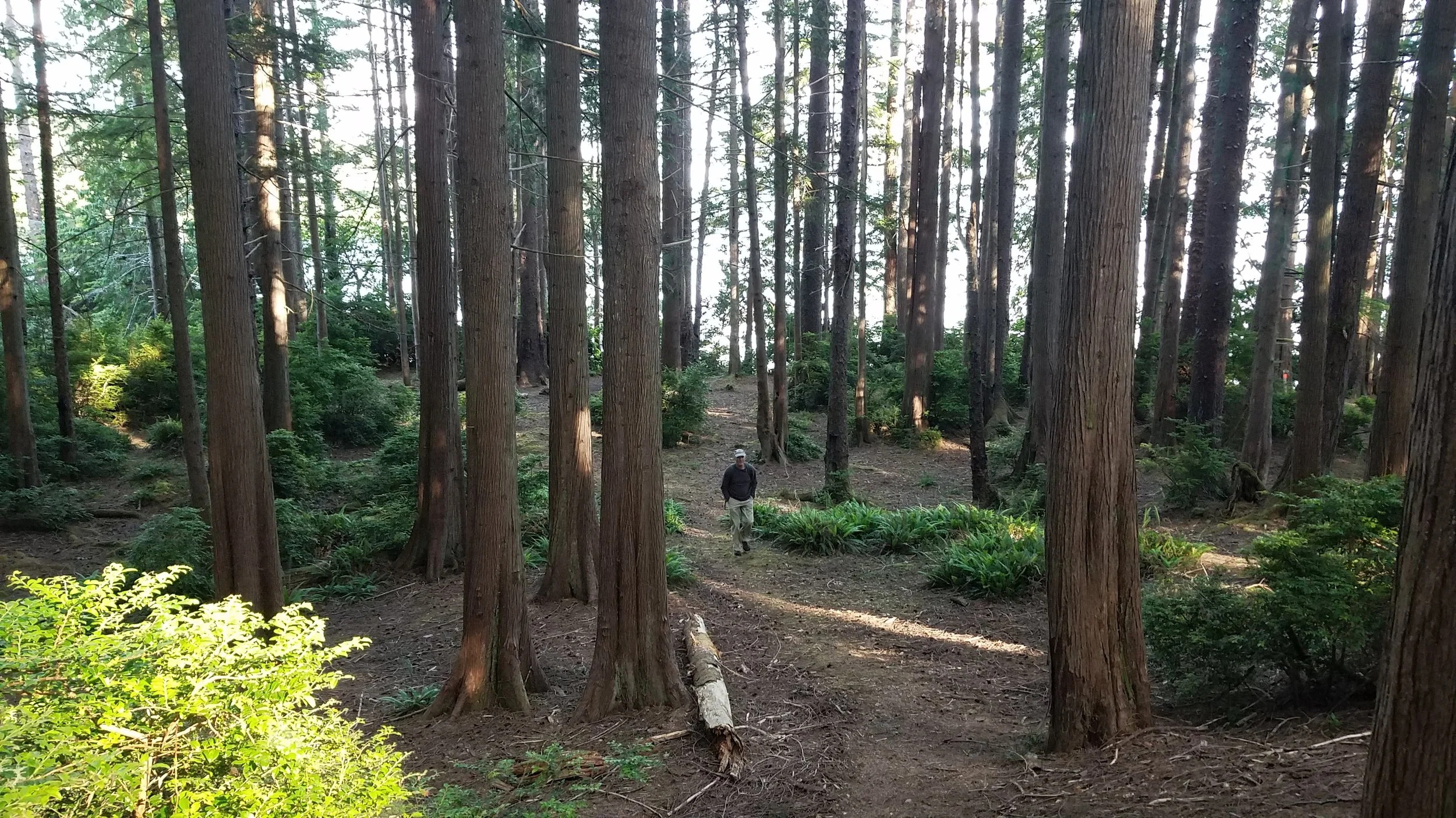
Erickson’s Bay campground on Lake Ozette features a very young, tidy forest of western red-cedars, ferns, and huckleberry and looks like a Hollywood set. Photo by MM Ruth.
We set up our tent and took a clothing-optional dip in the lake. The water was much warmer than I expected. Unlike other large lakes on the Olympic Peninsula (Quinault, Crescent), Lake Ozette is not fed by glaciers atop Mt. Olympus. The drainage basin to the lake is entirely beyond the reach of the icy tributaries. Lake Ozette is fed by many rivers, the largest being Big River and Umbrella Creek. Most flow through private timber lands—aka young forests, clearcuts, lack of shady, cooling tree canopy.
The lake was also much more shallow than we anticipated. Though the lake is 331 feet deep at its deepest, we had to walk across twenty feet of soft sand, twiggy branches, and forest duff to get into water deep enough to swim in.
Here in the sunny shallows of Erickson’s Bay, Lake Ozette was anything but intimidating. I felt more like the kiddie pool at a community aquatic center: a good place to test the waters and refreshing once I got out.

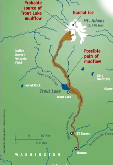
For a wild trail to the coast (dashed red lines), boaters can access the boat-in-only trailhead just a mile south of Erickson’s Bay. The better maintained trails (solid red line) to the north form two sides of the popular “Ozette Triangle” and can be accessed from the Ozette Ranger Station.
The next day, we packed a lunch and my swimming gear and canoed south to find a trail to the coast. This was not one of the two well-traveled trails of the Ozette Triangle, but a primitive (as in not marked or maintained) trail that serves as an evacuation route from the coast in case of a tsunami. We beached the canoe and walked two miles through the woods. It was totally enchanting, lush, and was the home of enormous Western red-cedars and Sitka Spruce.

The enchantingly primitive tsunami evacuation trail starts one mile south of Erickson’s Bay on Lake Ozette. Photo by MD Ruth.
We had the entire trail to ourselves. The plank boardwalk is quite dilapidated (and possibly dangerous even if you are not rushing to beat a tsunami toward). This turned out for the best as it slowed our pace down. We had to be careful with every step, which meant we stopped often to look around and admire the giant trees. After our picnic on the beach, we returned to our canoe--my husband to his lifejacket and paddle and me to my wetsuit and goggles. And off I went—swimming back home to Erickson’s Bay.
I’m always a bit breathless when I start a swim. I am never sure if it’s nerves or just a matter of getting up to speed aerobically before I get in an easy rhythm and groove. Having my husband shadow me in the canoe on my left side made me feel safe and also provided a visual marker to keep me on track. I breathe on my left side when I swim and caught a reassuring glimpse of the green canoe with every breath. Though the water was plenty warm enough (75?) to swim without a wetsuit, I wore it for extra buoyancy (and ease swimming) and also to prevent the possibility of hypothermia. Even if we think the water is “warm,” hypothermia can set it if you’re in it long enough.
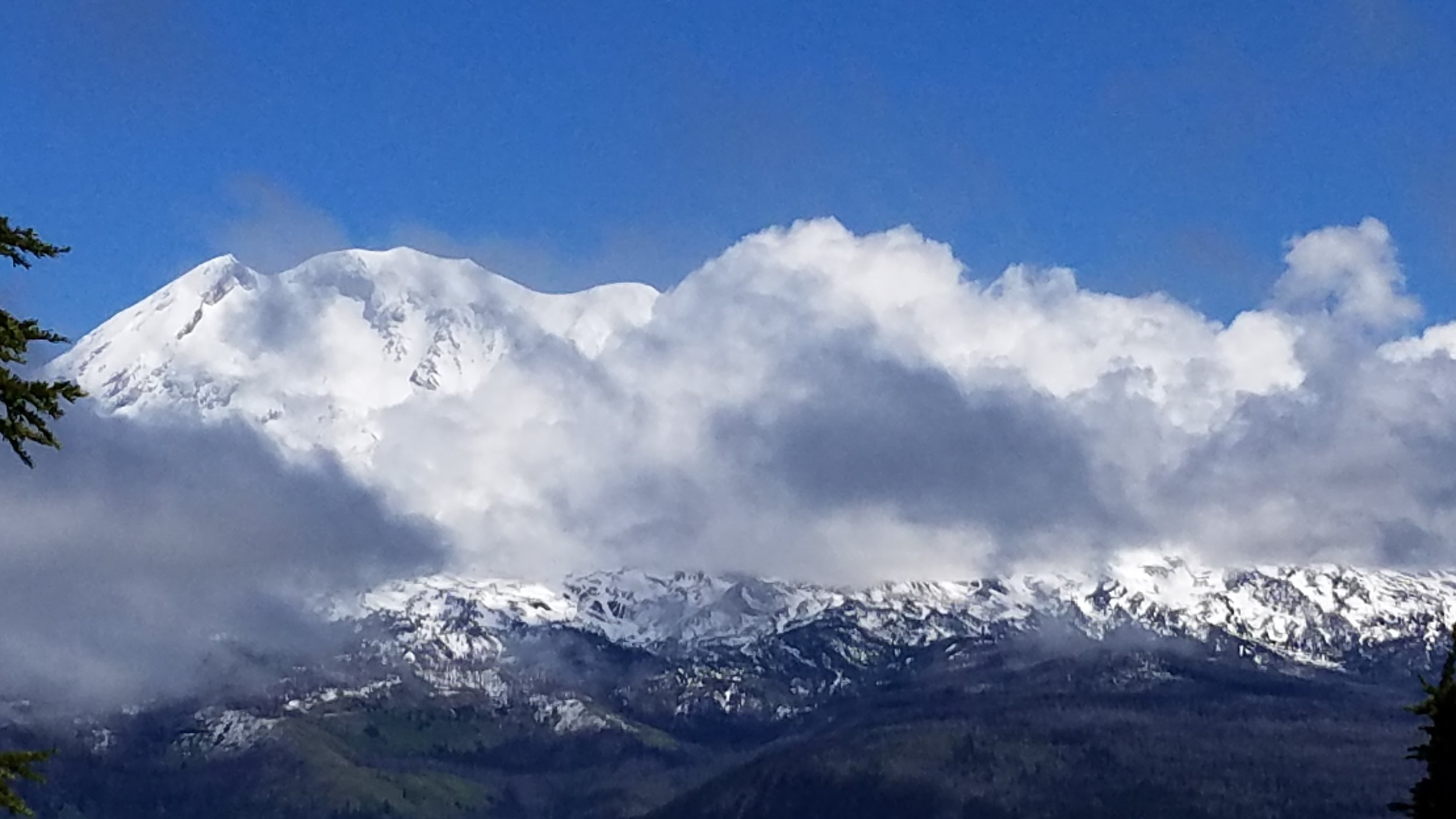
I moved across the lake in my usual medley of crawl, backstroke, breast stroke, and floating on my back to take in the sky and clouds and expanse of the lake. Oh, and an Esther Williams’ moment, too. The lake was a tawny tannin color and I could see the bottom clearly as I hugged the shore. I ventured a bit further out, lost sight of the bottom, and had a wee surge of “freak out” and returned to shallower water. Why the freak out? I can’t really say but I am interested in exploring the idea that everyone has a comfort zone in the water—a certain depth, a certain distance from shore, a certain level of surface chop. I swim regularly sans freak-out in a lake that is 65 feet deep. I cannot see the bottom but I can always see my feet clearly. I can see the entire shoreline. Lake Ozette was different—unfamiliar, a bit murky, a bit too vast to feel a kind of hug from the shoreline. I tried to embrace the vastness of Lake Ozette, which turned out to be easy once I turned onto my back and looked into the big beautiful sky and clouds overhead. I had forgotten that I can rely on my old pals, the clouds, for perspective.

Lake Ozette Wild Swim—just a mile from tsunami trail to Erickson’s Bay on June 26, 2019. Photo by MD Ruth