• Home
  • Author
  • Clouds
  • Blog
  • Events
  • Rare Bird
  • Marbled Murrelets
  • Lakes
Menu

Maria Mudd Ruth

Street Address
City, State, Zip
Phone Number
author and naturalist
Homepage-Banner.jpg

Maria Mudd Ruth

  • Home
  • Author
  • Clouds
  • Blog
  • Events
  • Rare Bird
    • Rare Bird
    • Marbled Murrelets
  • Lakes

Washington Lakes--Lost and Found

June 29, 2019 Maria Mudd Ruth
Take your hip waders but leave your wet suit and swimming goggles in the car.

Take your hip waders but leave your wet suit and swimming goggles in the car.

This is Disappearing Lake in the Gifford Pinchot National Forest the Mount Adams Ranger District in Klickitat County. It’s part of the gorgeous South Prairie and functions as a wetland and prairie in the summer, a basin for holding rain, snow, and ice in the fall and winter, and a lake for a very short period in the spring.

You’ve probably heard of Mt. Hood (second largest volcano in Lower 48), the town of Hood River, Oregon (famous as a wind-surfing, soft-fruit, and craft-beer mecca) and it’s sister town, White Salmon, Washington (white-water rafting, mellow non-Hood-River vibe). You may also be familiar with Gifford Pinchot National Forest—the 1.3 million acres of forested land stretching north from the Columbia River gorge.

As a day hiker who defaults to the Olympic Peninsula and Mt. Rainier for recreating, I have only occasionally visited this beautiful part of Washington State. A few times to hike in the Gifford Pinchot National Forest and once to survey for the egg masses of the endangered Oregon Spotted Frog. Never once did I hear or read about Disappearing Lake or the lake from which the town of Trout Lake gets its name.

Not until I began my research on Washington Lakes and lake swimming and watched a 2014 episode of Oregon Field Guide (it’s just 6 minutes long, worth a viewing) did I learn about Disappearing Lake. It doesn’t show up on most maps or Forest-Service road signs. It’s just called South Prairie. Which makes sense. It’s part of an extensive prairie south of Mt. Adams and is a prairie from mid-summer to late-fall and then, when the rains come the prairie begins to fill with water. The water that fills a lava tube freezes and acts like a plug in a bathtub. The prairie fills up with rainwater and snow and, in late spring, emerges as a beautiful lake you can canoe and kayak on if you time it right. Like most of my wilderness adventures (see my blog on Banks Lake), I’m always a bit off on my timing of natural spectacles. We arrived in mid-June having just missed the canoe-able—and I had hoped chilly-but-swimmable—period of Disappearing Lake. Alas, I’d pack my wetsuit again next spring and be ready to head to the lake on a moment’s notice to try again.

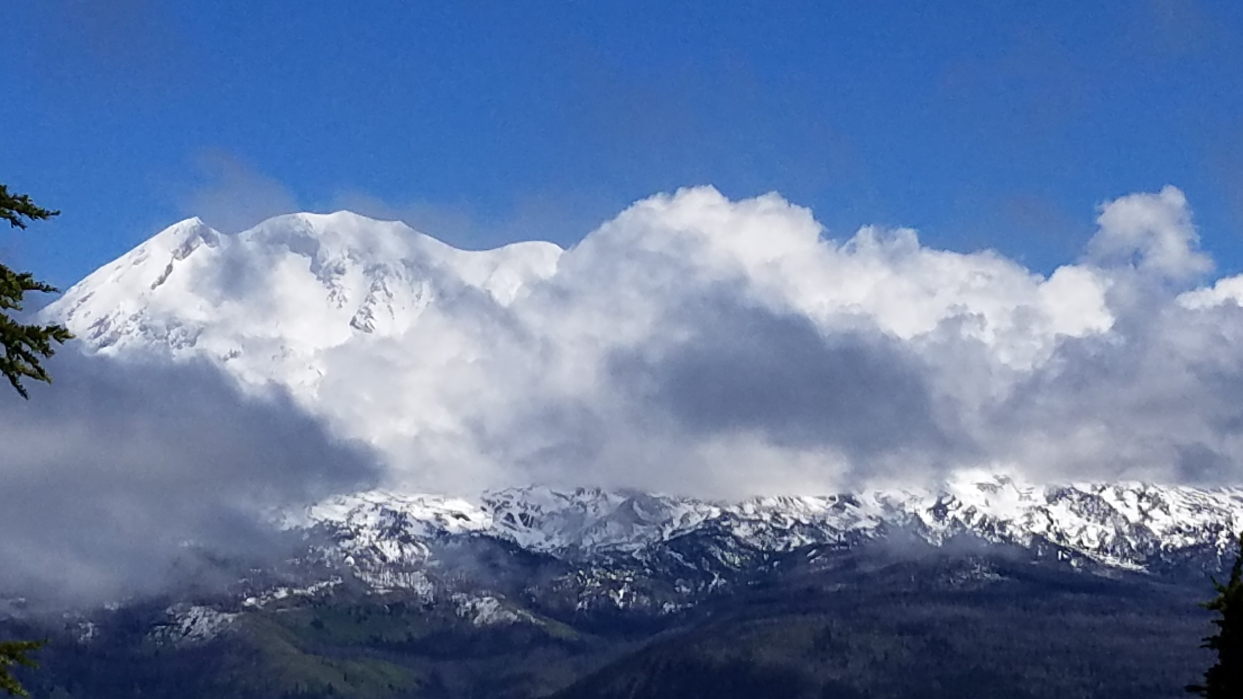
Not wanting to feel foolish about driving for 4 hours with a canoe strapped to the top of our car and not getting it wet, we headed for Goose Lake. But it was raining heavily that Friday afternoon and there was a fishing derby on the lake the next day. So my husband and I up Sleeping Beauty instead for bit of aerobic exercise and a spectacular view of Mt. Adams dancing with the cumulus clouds. What could top this as a consolation prize?

Mt. Adams and the clouds from atop a rock formation known as “Sleeping Beauty.”

Mt. Adams and the clouds from atop a rock formation known as “Sleeping Beauty.”

On the way back from the hike, we drove through the town of Trout Lake, wondering exactly the eponymous lake was and why there were no signs (not even the subtle Forest Service brown ones) advertising its presence. My husband had a hunch we might have luck following Lake Rd. a road marked as a Dead End. A few minutes later, we parked our car at a classic wooden kiosk and were happy to discover we needed a Discovery Pass. We had arrived at the Trout Lake Natural Area Preserve (NAP) managed by the Washington Department of Natural Resources (DNR). The lake was part lake, part creek, part wetland and a hot spot for the endangered Oregon Spotted Frog.

Screen Shot 2019-06-13 at 5.39.07 PM.png
Screen+Shot+2019-06-13+at+5.40.16+PM.jpg

On our left was an interpretive trail that hugged the southwest side of the creek and wetland. Here we learned that an avalanche of volcanic debris and mud, known as a lahar, flowed down from Mt. Adams about 6,000 years ago. The lahar traveled some 35 miles, following the river channels and leaving deposits as thick as 65 feet. The lahar raised the floor of the White Salmon River, thus blocking one of its tributaries—today’s Trout Lake Creek. The newly formed lake was much more extensive than it is today; sedimentation, especially over the last 50 years, has been filling in the open lake, increased the wetlands.

Screen Shot 2019-06-29 at 8.13.34 AM.png

After our short trail walk, we returned to our car and noticed a pair of flip-flops on the muddy edge of the water. That was the only sign I needed that it was time to grab my wetsuit and goggles and launch the canoe.

20190609_110110.jpg

We weren’t sure if we’d be paddling in a creek or a lake or deadend in a meadow of reed canary grass or for how long before we got stuck, but the water called. To our delight and amazement, we paddled for a good 30 minutes up the most gentle, intimate little waterway a Discover Pass could buy. The shore was undeveloped the bank was tangled with all the makings of a Hollywood riparian buffer: reeds, sedges, rushes, grasses, willows, snags, and cottonwood trees further off. Paddling upstream was easy and the water so inviting.

20190609_124242.jpg

We pulled off in an eddy at a very grassy spot and, with Oregon Spotted Frog tadpoles wiggling around my toes, I braced myself for a plunge into the clear cold water flowing off Mt. Adams in the distance.

20190609_122540.jpg

Despite my attempt at looking relaxed (what’s with my right foot?), it was nearly impossible to go gently into that good lake. Or any lake-river that takes your breath away and leaves you uttering ridiculous but ultimately helpful self-motivating phrases.

Getting upstream was harder than I thought. But worth the effort. My first-ever downstream swim was like flying.

In Lake Swimming, Geology of Washington, Lakeside Geology, Natural History, Open-water Swimming, Volcanoes, Washington Lakes, Wild Swimming, Wild Swimming Washington Tags Lake Swimming in Washington, Trout Lake Washington, Disappearing Lake, Gifford Pinchot National Forest, Mt. Adams Washington, Department of Natural Resources, Natural Area Preserve, Outdoor Swimming

The Problems with Clean Energy

January 16, 2019 Maria Mudd Ruth
But it looks so clean!

But it looks so clean!

Washington Governor Jay Inslee says tackling climate change is our state’s “hour to shine,” but we should be under no illusions about new forms of so-called “clean energy,” especially from wind turbines.

But they look so clean! There they are, dotting the ridge lines across the landscape, turning their blades in the fresh breeze, harkening back to old-fashioned Dutch windmills or a brightly colored pinwheel toy from our childhood. What’s not to like? Much.

I have just finished writing a set of public comments critical of the Skookumchuck Wind Energy Project—a 38 wind-turbine facility proposed to be built in Lewis County (south of Olympia, east of Centralia). Why do I get to criticize this project? Because the Lewis County Community Development Department determined the project will have a significant adverse impact on the environment. How ironic! Under state laws, this determination triggers an environmental review, In this case, the “environment” encompasses the habitat of several species of wildlife listed by the state or federal government as threatened, endangered, or in need of special protection and so these species are expected to be adversely impacted by the project. “Adverse impacts” generally means the species are at risk of being directly or indirectly killed or harmed by the project.

And by “project” we are talking about not only the 38 wind turbines (each 500 feet tall) but also the 120 towers and 17 miles of transmission lines that carry the energy produced by the turbines to Puget Sound Energy’s substation where it is fed into the grid. The towers will look something like this:

An estimated 17 miles of energy generator transmission tie lines (“gen-tie lines”) and and 120 towers are included in the Skookumchuck Wind Energy Project.. Photo by Stefan Andrej Shambora (St_A_Sh), CC BY 2.0, https://commons.wikimedia.org/w/index.…

An estimated 17 miles of energy generator transmission tie lines (“gen-tie lines”) and and 120 towers are included in the Skookumchuck Wind Energy Project.. Photo by Stefan Andrej Shambora (St_A_Sh), CC BY 2.0, https://commons.wikimedia.org/w/index.php?curid=9431898

Why am I concerned? Because this project, located on Weyerhaeuser property, is sited in the Pacific Flyway for migratory birds (68 species document at the site), is a place where both Bald and Golden Eagles are common, and is on the commuting route of the endangered Marbled Murrelet—the seabird that flies through the project area en route between the Pacific Ocean and/or Puget Sound to the west and north and its nesting habitat on federal forestland at the eastern edge of the project. The proponents of the project, RES-Americas, estimates that 2.496 Marbled Murrelets will be “taken” (killed) each year as well as 4.86 Bald Eagles and 1.65 Golden Eagles during turbine operations. They are not willing to take responsibility for adverse impacts to these birds or any other wildlife during the year-long construction phase of the project when birds could be at risk for colliding with turbines, towers, and get tie-lines. This means that over the 30-year lifespan of this “clean” energy project, we are likely to lose 75 Marbled Murrelets, 66 Bald Eagles, and 23 Golden Eagles, not to mention untold numbers of migratory birds as well as bats that occur in the project area.

To its credit, RES-Americas has worked diligently to figure out ways to minimize the toll on these special-status birds and they have grappled nobly with the strange and somewhat unpredictable breeding behavior of the Marbled Murrelet, whose remarkable life history hovers on the edge of possibility. Since 2001, Washington state has lost 44% of our murrelet population. The loss of its nesting habitat—our coastal old-growth and mature forests—as well as the depletion of the fisheries that supply its food, oil pollution, and entrapment in fishing nets, and a host of habitat-degrading problems have all caused this decline. And then there’s climate change and its impacts on both the marine and forest ecosystems to which murrelets belong.

To some the murrelet is doomed and therefore why not throw 38 spinning turbines and 120 transmission towers in its way? Why not log this parcel of land, or this one, or this one? There are so many forces at work against the murrelet’s survival that no one person, agency, or corporation could possibly be accused of dealing the fatal blow. If no one can prove that the Skookumchuck Wind Energy Project caused of the deaths of the murrelets nesting nearby, or contributed to the loss of the murrelet population barely hanging on in Southwest Washington, or proverbially hammered the nail in the coffin of the 4,913 murrelets left inWashington —then who is? The Washington Department of Natural Resources? The U.S. Forest Service? The U.S. Fish and Wildlife Service? Private timber companies? The salmon gill-net fisheries? There will be such a feast of finger pointing that guilt for this crime won’t stick to anyone. But we’ll all feel it.

We’ll tell ourselves that we address climate change NOW! We must reduce human impacts on the environment NOW! We must wean ourselves from fossil fuels NOW! We need to divest our money and our souls from the dirty oil and the dirty coal that visibly pollutes our water, air, and soil. We need to tax the polluters, educate the wasteful, and “green” our economy! We need to install big, beautiful, white wind turbines across our landscape. Everyone for miles around needs to see us conspicuously generating clean energy!

Few of us will see the hundreds of bird carcasses on the ground beneath these symbols of clean energy. That job will be left to an unlucky few hired to conduct carcass searches beneath the turbines. Has any one considered that the birds using the Pacific Flyway to move northward into a cooler climate may not be able to navigate through this clean-energy obstacle course? How many birds will fatally collide with the very turbines installed in part to reduce the fatal impacts of climate change on these birds?

When operational, the proposed Skookumchuck Wind Energy Project will produce 137 megawatts of electricity. My annual electrical bill from Puget Sound Energy (PSE) is TK kilowatts. So this project could potentially power TK homes. Given the population growth in our region, this energy will not be used to replace but to supplement our current energy needs. The Evergreen State may become forested with forests of wind turbines—sterile forests where no trees grow and no birds sing.

So, Governor Inslee, how about some truly conservative policies—that is, ones based on actually conserving energy? Remember former President Jimmy Carter asking the American people to waste less energy? This was in 1979—forty years ago! (Interesting Carter didn’t ask us to use less, just to waste less!) Watch a short excerpt from his speech to the American people on energy here.

Screen Shot 2019-01-16 at 2.40.20 PM.png

Frumpy cardigan aside, what’s wrong with an extra layer of fleece? How about turning your thermostat down to 65F in the day and 55F at night (you’ll sleep better, trust me!). How about unplugging a few energy-sucking appliances, electronics, and gizmos? Would you not make some minor life-style changes to save a Marbled Murrelet? A Bald or Golden Eagle? What about a Peregrine Falcon, Pileated Woodpecker, Olive-sided Flycatcher, Vaux’s Swift, special-status bats, and any of the 68 migratory bird species flying in harm’s way?

We expect bird, bats, and other wildlife to change their habits, to fly around or over thousands of acres of enormous turbines and towers and electrical lines, to forage and nest elsewhere, and to adapt quickly and successfully to whatever impediments we decided to place in their environment. As we modify and degrade wildlife habitat in the name of “clean energy” and “progress,” we are forcing our wildlife to spend get by with less. Because we refuse to do so ourselves. This is the dirty little secret clean energy. We can do better.

Despite my criticism, the Skookumchuck Wind Energy Project has the potential to be a model project for Washington state and for any place where wildlife is abundant, imperiled, at risk. So everywhere. In my view, the project needs to be downsized. Operations of turbines needs to be curtailed during murrelet breeding season. And the investors need to rethink their expected (large) profits.

There are plenty of very smart and motivated people developing new wind-energy technologies that don’t cause more harm than good. The American Wind and Wildlife Association is leading the way on this front. Check out this uplifting video that gives a glimmer of hope as we navigate our way through our energy crisis. Skookumchuck Wind Energy Project can help us find the win-win in wind energy.

In Endangered Species, Marbled Murrelets, Maria Mudd Ruth, Volcanoes Tags conservation, murrelet conservation, wind energy turbines, skookumchuck wind energy project, American Wind and Wildlife Association, myth of clean energy
Comment

Battle Ground Lake

July 14, 2018 Maria Mudd Ruth
Battle Ground Lake on July 12, 2018 . This lovely 27-acre crater lake is 4 miles northeast of Battle Ground, WA, in Battle Ground State Park. (Photo by M. M. Ruth)

Battle Ground Lake on July 12, 2018 . This lovely 27-acre crater lake is 4 miles northeast of Battle Ground, WA, in Battle Ground State Park. (Photo by M. M. Ruth)

This does not look like the kind of place I would expect to find in a place called Battle Ground, Washington. Nor the kind of place I would associate with a volcanic eruption. Battle Ground Lake is  too peaceful, beautiful, and lush. And, on one of the hottest days of Summer 2018 so far, it was a place full of happy human beings enjoying the simple pleasures of a cool lake in a state park. Listen:

There were hundreds of people on one side of the lake at a small beach area, picnic tables, a dock, and restrooms. Everyone seemed happy. It was as if everyone checked any grouchiness and stress at the entrance gate. Whether people arrived with picnic coolers, silly inflatable floating devices, swim goggles, kayaks, stand-up boards, beach chairs, or paperback books, everyone was enjoying themselves and--it seemed to me--happy others were enjoying themselves. Even when, late in the afternoon, someone cranked up their boombox with classic rock and roll hits--no one glowered or complained. A few swimmers were actually dancing to "Eye of Tiger" as they stood waist-high in the water on the concrete boat ramp. 

The sounds from the shore created a pleasant summer din as my friend and I swam the perimeter of this 27-acre lake. We rested on logs floating along the lakeshore. We watched very small fish take an interest in our wiggling toes (big, fat worms!). Near the rope swing, we dog paddled to watch young teens scramble up the steep muddy hill and then swing out over the water for a plunge that looked so fun and sounded so refreshing it brought a smile to my face. 

Battle Ground Lake is named for a battle that never took place near present-day Battle Ground in 1855--a non-battle involving Klickitat tribes living on the Lewis and Cowlitz Rivers, U.S. troops stationed at Fort Vancouver, and  "friendly fire" mistakes. The origin of the town and lake name is not half as interesting as the origin of the lake itself. 

According to the U.S. Geologic Survey, Battle Ground Lake in Washington, a maar volcano, was formed when magma encountered water and blasted through a 100,000 year old lava flow. This is one of the youngest volcanoes in an area known as the Boring Lava Field, which extends east and north from the Vancouver-Portland area. Battle Ground Lake is one of 80 volcanic vents and associated lava flows evident in the area. Geologists believe many other vents were buried during the Missoula Floods.

The map below shows some of the Boring Volcanic Field. Battle Ground Lake is not shown here but is located in the orange areas at the top of the map, east of the I-5 and on the south side of the East Fork of the Lewis River. More on the Boring Volcanic Field from the USGS here.

Map image from USGS, Everts et al 2009

Map image from USGS, Everts et al 2009

The skyline in this region and its 1980 eruption is still so fresh in my memory that I have to remind myself that, even though Mount St. Helens transformed the local landscape, Mount St. Helens was not the only show in town. 

The lake I was swimming was created about 100,000 years  before Mount St. Helens' 1980 eruption. I knew I was swimming in an older landscape. I was swimming in a 60-foot deep lesson in local geology. I was swimming the cool refreshing legacy of ancient magma and boiling water. 

Evidence of Battle Ground Lake's geologic history is easy to see if you walk/hike the 1-mile long Lower Lake trail in the park. Here is a chunk of volcanic basalt with vesicles formed by trapped gas. The Lower Lake trail winds through mature evergre…

Evidence of Battle Ground Lake's geologic history is easy to see if you walk/hike the 1-mile long Lower Lake trail in the park. Here is a chunk of volcanic basalt with vesicles formed by trapped gas. The Lower Lake trail winds through mature evergreen forest--and offers plenty of shade, access points to the lake and the rope swing. (Photo by M.M. Ruth)

For more information,  WA State Park website or  Washington Trails Association website for a description of the Lower Lake trail. More on the Boring Volcanic Field from the USGS's Cascades Volcanic Observatory here.

In Lake Swimming, Open-water Swimming, Washington Lakes, Volcanoes, Geology of Washington, Lakeside Geology Tags Battleground Lake, Battleground Lake State Park, Open-water Swimming, State Parks, Swimming Lakes in Washington, Crater Lake, Battle Ground Lake, Battle Ground Lake State Park, Wild Swimming
Comment

Subscribe

Sign up with your email address to receive my blog in your inbox.

Thank you!
​Connect with Maria elsewhere  Facebook Instagram
Blog RSS

A Sideways Look at Clouds from Mountaineers Books

A Sideways Look at Clouds from Mountaineers Books

Rare BirdORDER TODAY >>

Rare Bird: Pursuing the Mystery of the Marbled Murrelet

“Compelling…  engaging.” —Library Journal

“Rare insights into the trials and joys of scientific discovery.” —Publisher’s weekly

Learn more about Rare Bird...

Enjoy this song by Peter Horne, "Little Bird, Little Boat, Big Ocean... 


The photo for my blog captures the spirit of the accidental naturalist (my husband, actually). The body of water featured here, Willapa Bay, completely drained out at low tide during our camping trip at the Willapa National Wildlife Refuge, leaving …

The photo for my blog captures the spirit of the accidental naturalist (my husband, actually). The body of water featured here, Willapa Bay, completely drained out at low tide during our camping trip at the Willapa National Wildlife Refuge, leaving us a pleasant several hours of experiencing the life of the turning tide.

  • Wild Swimming
  • marbled murrelet
  • clouds
  • A Sideways Look at Clouds
  • Mountaineers Books
  • Rare Bird
  • old-growth forests
  • Open-water Swimming
  • Maria Mudd Ruth
  • Lakes of Washington
You must select a collection to display.

Subscribe

Sign up with your email address to receive my blog in your inbox.

Thank you!
​Connect with Maria elsewhere  Facebook
Blog RSS

©2025 MARIA MUDD RUTH  |  ALL RIGHTS RESERVED