• Home
  • Author
  • Clouds
  • Blog
  • Events
  • Rare Bird
  • Marbled Murrelets
  • Lakes
Menu

Maria Mudd Ruth

Street Address
City, State, Zip
Phone Number
author and naturalist
Homepage-Banner.jpg

Maria Mudd Ruth

  • Home
  • Author
  • Clouds
  • Blog
  • Events
  • Rare Bird
    • Rare Bird
    • Marbled Murrelets
  • Lakes

Stages of a Winter Wild Swim

February 24, 2021 Maria Mudd Ruth
Munn Lake looks so alluring before and after a winter swim It’s real allure during a swim is difficult to define.    (Photo my M.M Ruth)

Munn Lake looks so alluring before and after a winter swim It’s real allure during a swim is difficult to define. (Photo my M.M Ruth)

My friend and I had planned a swim on Saturday but it took until Tuesday to finally get in the water. The air was 42 degrees F, the water 46. This does not add up to 100, which is the number someone recommended as a guide to “swimmable” water in “tolerable” air, but we had done 88 before and so proceeded. Someone asked me recently why I swim in really cold water. I will try to explain. 

There are three parts to the swim: the before, the during, and the after. 

The “before” includes picking a day and time with my friend; dreading the swim (four days’ worth for this particular swim); getting into my bathing suit, fleece, wool socks, wool hat, and dry robe; dreading the swim some more; making hot tea; driving to the lake; standing at the edge of the lake waiting for my brain and body to get in sync and to decide that at this moment right now…now…now (oh, one more photo)…that at this moment now the “before” stage is over. 

Self portrait of author while author’s hippie-hatted brain struggles to convince author to stay out of the 46-degree water. Shortly after photo was taken, author told brain to “get over it.”    (Photo by M.M. Ruth)

Self portrait of author while author’s hippie-hatted brain struggles to convince author to stay out of the 46-degree water. Shortly after photo was taken, author told brain to “get over it.” (Photo by M.M. Ruth)

Then the “during” begins with accompanying my bathing suit and wool hat into the water, slowly, up to my waist. My friend is similarly clad and nearby, but she moves more peacefully and steadily. We dip our hands in, splash water on our arms, rub our cold wet hands on our faces, look at the lake and clouds and trees. We talk to ourselves and to each other. We say things like, “Okaaaay!” “Here we go!” “We can do this!” And we do. We just drop so that the water rushes over our shoulders. I flip onto my back and kick and paddle my hands like egg-beaters and try to not scream and sing an operatic off-key note but usually fail. That I am in this very cold lake is bizarre. That I am not crying or weeping or miserable is astonishing. That I am smiling and laughing with my friend is a wild and wonderful gift.

Yes, I am very cold. 

Despite my constant thrashing, my hands tingle to the point of discomfort. Is this pain? I am not sure. It’s a feeling. But it’s a sign that if I get out much further in the lake or stay in much longer, my hands—and then arms and legs—will not work well enough to get me back to shore. Keep in mind we are about 30 feet from shore but in water over our heads. We stay in maybe ten minutes then breast stroke toward shore. My friend hands me her wool hat, she dives underwater, and emerges with an even bigger smile. I am not there yet, but soon. I am still seeking and hoping to destroy my idiopathic resistance to putting my head under water.

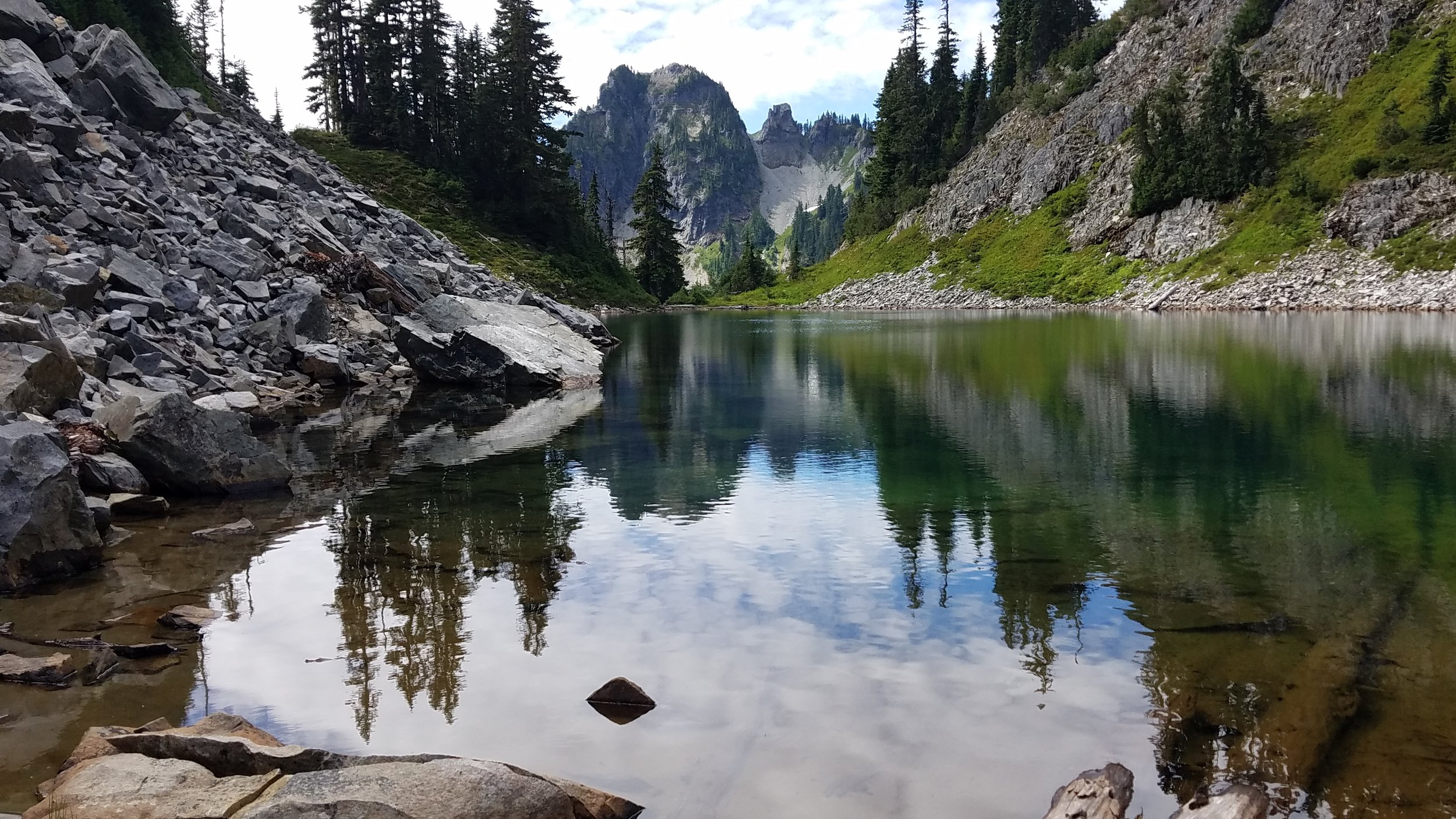
The “after” of the swim begins when our feet touch the bottom of the lake—about ten feet from the shore—and we lunge for our dry robes, exchange wet suit for dry fleece pants and sweater, and then wrap our hands around a cup of hot tea.  We talk. We warm up. We admire the colors and textures of the water, the reflections of the clouds, the harmony of water and sky and trees. 

As we begin to feel a bit of post-swim euphoria (endorphins? relief? gratitude?), we slowly head to our cars where one of us will undoubtedly say, “That was perfect. We should swim again soon.” We are vague about when. Here in the “after,” I am not quite ready to start another “before”. I think of a stanza in Wallace Steven’s poem, Thirteen Ways of Looking at Blackbird:

I do not know which to prefer,   

The beauty of inflections   

Or the beauty of innuendoes,   

The blackbird whistling   

Or just after.   

At the lake, we do not have to choose. We enjoy both the inflection and innuendo, the whistling and the silence, the water and the air, the during and the after. 

The “after” is a really wonderful time and is in no way sponsored by dryrobe, though they do make the before and after quite pleasant, even toasty.   (Photo by M.M. Ruth)

The “after” is a really wonderful time and is in no way sponsored by dryrobe, though they do make the before and after quite pleasant, even toasty. (Photo by M.M. Ruth)

In Wild Swimming Washington, Wild Swimming, Washington Lakes, Open-water Swimming, Lake Swimming, Clouds Tags Wild Swimming, Lakes of Washington, Munn Lake, Cold-water swimming, dry robe

“I Need to Show You This Lake...

September 2, 2019 Maria Mudd Ruth
Shhhhhh.                                                                                                                                           Photo by M. M. Ruth

Shhhhhh. Photo by M. M. Ruth

…only I can’t tell you where it is and you can’t tell anyone once we show it to you.”

Over the summer a few of my fellow lake-swimming enthusiasts have been kind enough to take me to their secret lakes as long as I promised not to provide the name or directions to others. I’ve found these secrets easy to keep because Washington state boasts thousands of swimming lakes. I feel lucky to live in a landscape so pervious, pock marked, glacier scoured, and potholed that the secret holders are not depriving anyone of the experience of lake swimming.

Most of our swimmable lakes are accessible by public boat ramp, dock, beach, or trail. The secret lakes require way-finding skill and sometimes a bit of bushwhacking. Trail markers and cairns are entirely absent.

None of the secret lakes I’ve been to have official names and don’t always appear on maps. They become known because someone discovers them and then they tell a friend who tells two friends and so on. And, while I might tell you about these lakes, I cannot for the life of me retrace my steps to return to them or describe the roads and routes and landmarks that would get you anywhere but lost.

Photo by M.M. Ruth

Photo by M.M. Ruth

So it was this past when when two friends guided me on a hike-scramble to this beauty. It was the clearest water I have ever swum in—so clear that it is easy to forget it is water. So clear that, as one friend said, “it’s hard to remember not to breathe it.”

It was what I might once have called “freezing” but now, after months of lake swimming, I’ll call it perfectly delightful cold. We swam, floated and swam some more. When the clouds parted and the sun shone down on the lake, we warmed up on the rocks on the far shore. The lake was silent save for the occasional squeak of a pika and the clattering wings of the grasshoppers echoing against the rocks and cliff. There was no human presence at all—just wilderness all around.

While the sun warmed our skin it also warmed the thin skin of the lake. When we slipped back into the water, the top few inches of the lake had noticeably warmed. To preserve that layer of warm water, we swam slowly without kicking and churning up the cold water beneath. I stretched out on my back and floated, spinning slowly around to memorize the contours of the shore, hill, and peaks and to take in the last bit of summer’s warmth.

I left the water and walked down the sandy shoreline toward my towel, lunch, and thermos of hot tea. I walked slowly, scanning the edge of water for newts. Something caught my eye. There on the beach, scrawled in the sand in all capital letters:

ONLY

WITH

SOUL

In Lake Swimming, Natural History, Open-water Swimming, Washington Lakes, Wild Swimming, Wild Swimming Washington Tags Lakes of Washington, Lake Swimming in Washington, Wild Swimming

Lake Ozette Wild Swim

August 4, 2019 Maria Mudd Ruth

Lake Ozette sprawls across the remote northwest corner of Washington just a mile from the Pacific Ocean. The lake was named for the village of Ozette, a now-abandoned whaling village occupied from 440 BC to 1750 AD by the Makah peoples. Lake Ozette’s waters, shoreline, and buffering forest fall entirely within Olympic National Park.

In terms of superlatives, Lake Ozette ranks as one of Washington’s top three largest natural, undammed lakes. Establishing the exact ranking is a challenge. Lake Washington is often cited as the first orsecond largest undammed lake and Lake Chelan still gets listed as second largest despite the fact that it was dammed in 1927.

No matter, Lake Ozette is immense as an ocean to a wild swimmer. This wild and undeveloped lake is about nine miles long and averages two miles across (for a total of 12 sq. mi) and is 331 feet deep at its deepest point. It shoreline and bathymetric contour lines are convoluted.

The convoluted shoreline of Lake Ozette makes it a great place to explore by canoe—plenty of bays, coves, points, nooks, crannies, and few uninhabited islands.

The convoluted shoreline of Lake Ozette makes it a great place to explore by canoe—plenty of bays, coves, points, nooks, crannies, and few uninhabited islands.

The lake’s shoreline is undeveloped. There is a ranger station, campsites, parking lot, restrooms, and boat launch at the north end of the lake and a boat ramp on the eastern shore. Most visitors to Lake Ozette do not come to swim or even boat on the lake, but to hike the ~3-mile mostly board-walked trails to the Pacific Coast at Sand Point or Cape Alava, or hike the “Ozette Triangle,” which includes these trails and (tide willing) the stretch of beach between then camp along the coast. I was there to swim. 

There are no designated swimming beaches on Lake Ozette. In fact, there is no information at all at the ranger station or in my guide books about swimming in the lake. I have discovered that our state’s lakes are underswum; they merely give their names to trails, provide a scenic destination for a picnic, or offer a place to fish. Swimming is rarely, if ever, mentioned as a possibility. Which is a shame. For me, there is no better trail’s-end reward than a refreshing swim.

Given its size, remoteness, and proximity to the ocean, I have always thought of Lake Ozette as intimidating though I had never visited to find out for myself. To discover the best swimming spot and also to swim safely, my husband and I set aside two days in late June to explore the lake in our Penobscot 16 canoe and camp at Erickson’s Bay on the lake’s west shore. The weather was warm, the air calm, and I had my wetsuit and had been lake swimming since March. I was as ready as I’d ever be. 

We launched our canoe at Ozette and paddled south on lightly choppy water for four miles toward Erickson’s Bay. We had the entire lake to ourselves, minus a family of mergansers.

Despite the fact that Erickson’s Bay is a boat-in-only campsite, I was expecting the place to be swarming with boats and campers who had arrived ahead of us. Much of the Olympic National Park has been designated the Daniel J. Evans Wilderness and to reduce the human impact in these areas, there is now a permitting systemin place for overnight camping. Along the coast west of Lake Ozette are limited to just a few sites; Erickson’s Bay was listed as having “99+” sites—in other words, it was a large site with a virtually unlimited number of permits. 

As we paddled toward the shore of the bay, we did not see a single canoe, kayaked, or anchored motor boat. We did not see a single sign marking the way to the camping area. The only indication that we were on target was a break in the shoreline salad hedge and a trail leading to a beautiful driftwood bench.

The only sign that you’ve arrived at the entrance to the primitive campground at Erickson’s Bay on Lake Ozette is this alluring driftwood bench. Photo by MM Ruth.

The only sign that you’ve arrived at the entrance to the primitive campground at Erickson’s Bay on Lake Ozette is this alluring driftwood bench. Photo by MM Ruth.

Civilization! We beached the canoe and walked up the trail. Not only was there the bench, there was a stone fire ring and a smooth flat spot for our tent. And a nearby privy. Before committing to this perfect bay-view site, we strolled through the forest and discovered not a single human soul, but a very tidy forest of young red-cedars and sword ferns.

Erickson’s Bay campground on Lake Ozette features a very young, tidy forest of western red-cedars, ferns, and huckleberry and looks like a Hollywood set. Photo by MM Ruth.

Erickson’s Bay campground on Lake Ozette features a very young, tidy forest of western red-cedars, ferns, and huckleberry and looks like a Hollywood set. Photo by MM Ruth.

We set up our tent and took a clothing-optional dip in the lake. The water was much warmer than I expected. Unlike other large lakes on the Olympic Peninsula (Quinault, Crescent), Lake Ozette is not fed by glaciers atop Mt. Olympus. The drainage basin to the lake is entirely beyond the reach of the icy tributaries. Lake Ozette is fed by many rivers, the largest being Big River and Umbrella Creek. Most flow through private timber lands—aka young forests, clearcuts, lack of shady, cooling tree canopy. 

The lake was also much more shallow than we anticipated. Though the lake is 331 feet deep at its deepest, we had to walk across twenty feet of soft sand, twiggy branches, and forest duff to get into water deep enough to swim in.

Here in the sunny shallows of Erickson’s Bay, Lake Ozette was anything but intimidating. I felt more like the kiddie pool at a community aquatic center: a good place to test the waters and refreshing once I got out.

For a wild trail to the coast (dashed red lines), boaters can access the boat-in-only trailhead just a mile south of Erickson’s Bay. The better maintained trails (solid red line) to the north form two sides of the popular “Ozette Triangle” and can b…

For a wild trail to the coast (dashed red lines), boaters can access the boat-in-only trailhead just a mile south of Erickson’s Bay. The better maintained trails (solid red line) to the north form two sides of the popular “Ozette Triangle” and can be accessed from the Ozette Ranger Station.

The next day, we packed a lunch and my swimming gear and canoed south to find a trail to the coast. This was not one of the two well-traveled trails of the Ozette Triangle, but a primitive (as in not marked or maintained) trail that serves as an evacuation route from the coast in case of a tsunami. We beached the canoe and walked two miles through the woods. It was totally enchanting, lush, and was the home of enormous Western red-cedars and Sitka Spruce.

The enchantingly primitive tsunami evacuation trail starts one mile south of Erickson’s Bay on Lake Ozette. Photo by MD Ruth.

The enchantingly primitive tsunami evacuation trail starts one mile south of Erickson’s Bay on Lake Ozette. Photo by MD Ruth.

We had the entire trail to ourselves. The plank boardwalk is quite dilapidated (and possibly dangerous even if you are not rushing to beat a tsunami toward). This turned out for the best as it slowed our pace down. We had to be careful with every step, which meant we stopped often to look around and admire the giant trees. After our picnic on the beach, we returned to our canoe--my husband to his lifejacket and paddle and me to my wetsuit and goggles. And off I went—swimming back home to Erickson’s Bay.

I’m always a bit breathless when I start a swim. I am never sure if it’s nerves or just a matter of getting up to speed aerobically before I get in an easy rhythm and groove. Having my husband shadow me in the canoe on my left side made me feel safe and also provided a visual marker to keep me on track. I breathe on my left side when I swim and caught a reassuring glimpse of the green canoe with every breath. Though the water was plenty warm enough (75?) to swim without a wetsuit, I wore it for extra buoyancy (and ease swimming) and also to prevent the possibility of hypothermia. Even if we think the water is “warm,” hypothermia can set it if you’re in it long enough.

 I moved across the lake in my usual medley of crawl, backstroke, breast stroke, and floating on my back to take in the sky and clouds and expanse of the lake. Oh, and an Esther Williams’ moment, too. The lake was a tawny tannin color and I could see the bottom clearly as I hugged the shore. I ventured a bit further out, lost sight of the bottom, and had a wee surge of “freak out” and returned to shallower water. Why the freak out? I can’t really say but I am interested in exploring the idea that everyone has a comfort zone in the water—a certain depth, a certain distance from shore, a certain level of surface chop. I swim regularly sans freak-out in a lake that is 65 feet deep. I cannot see the bottom but I can always see my feet clearly. I can see the entire shoreline. Lake Ozette was different—unfamiliar, a bit murky, a bit too vast to feel a kind of hug from the shoreline. I tried to embrace the vastness of Lake Ozette, which turned out to be easy once I turned onto my back and looked into the big beautiful sky and clouds overhead. I had forgotten that I can rely on my old pals, the clouds, for perspective.

Lake Ozette Wild Swim—just a mile from tsunami trail to Erickson’s Bay on June 26, 2019. Photo by MD Ruth

Lake Ozette Wild Swim—just a mile from tsunami trail to Erickson’s Bay on June 26, 2019. Photo by MD Ruth

In Lake Swimming, Open-water Swimming, Washington Lakes, Wild Swimming, Wild Swimming Washington Tags Lake Ozette, Erickson's Bay, Wild Swimming, Washington Lakes, Washington Lake Swimming, Ozette Triangle, Canoeing on Lake Ozette

Washington Lakes--Lost and Found

June 29, 2019 Maria Mudd Ruth
Take your hip waders but leave your wet suit and swimming goggles in the car.

Take your hip waders but leave your wet suit and swimming goggles in the car.

This is Disappearing Lake in the Gifford Pinchot National Forest the Mount Adams Ranger District in Klickitat County. It’s part of the gorgeous South Prairie and functions as a wetland and prairie in the summer, a basin for holding rain, snow, and ice in the fall and winter, and a lake for a very short period in the spring.

You’ve probably heard of Mt. Hood (second largest volcano in Lower 48), the town of Hood River, Oregon (famous as a wind-surfing, soft-fruit, and craft-beer mecca) and it’s sister town, White Salmon, Washington (white-water rafting, mellow non-Hood-River vibe). You may also be familiar with Gifford Pinchot National Forest—the 1.3 million acres of forested land stretching north from the Columbia River gorge.

As a day hiker who defaults to the Olympic Peninsula and Mt. Rainier for recreating, I have only occasionally visited this beautiful part of Washington State. A few times to hike in the Gifford Pinchot National Forest and once to survey for the egg masses of the endangered Oregon Spotted Frog. Never once did I hear or read about Disappearing Lake or the lake from which the town of Trout Lake gets its name.

Not until I began my research on Washington Lakes and lake swimming and watched a 2014 episode of Oregon Field Guide (it’s just 6 minutes long, worth a viewing) did I learn about Disappearing Lake. It doesn’t show up on most maps or Forest-Service road signs. It’s just called South Prairie. Which makes sense. It’s part of an extensive prairie south of Mt. Adams and is a prairie from mid-summer to late-fall and then, when the rains come the prairie begins to fill with water. The water that fills a lava tube freezes and acts like a plug in a bathtub. The prairie fills up with rainwater and snow and, in late spring, emerges as a beautiful lake you can canoe and kayak on if you time it right. Like most of my wilderness adventures (see my blog on Banks Lake), I’m always a bit off on my timing of natural spectacles. We arrived in mid-June having just missed the canoe-able—and I had hoped chilly-but-swimmable—period of Disappearing Lake. Alas, I’d pack my wetsuit again next spring and be ready to head to the lake on a moment’s notice to try again.

Not wanting to feel foolish about driving for 4 hours with a canoe strapped to the top of our car and not getting it wet, we headed for Goose Lake. But it was raining heavily that Friday afternoon and there was a fishing derby on the lake the next day. So my husband and I up Sleeping Beauty instead for bit of aerobic exercise and a spectacular view of Mt. Adams dancing with the cumulus clouds. What could top this as a consolation prize?

Mt. Adams and the clouds from atop a rock formation known as “Sleeping Beauty.”

Mt. Adams and the clouds from atop a rock formation known as “Sleeping Beauty.”

On the way back from the hike, we drove through the town of Trout Lake, wondering exactly the eponymous lake was and why there were no signs (not even the subtle Forest Service brown ones) advertising its presence. My husband had a hunch we might have luck following Lake Rd. a road marked as a Dead End. A few minutes later, we parked our car at a classic wooden kiosk and were happy to discover we needed a Discovery Pass. We had arrived at the Trout Lake Natural Area Preserve (NAP) managed by the Washington Department of Natural Resources (DNR). The lake was part lake, part creek, part wetland and a hot spot for the endangered Oregon Spotted Frog.

Screen Shot 2019-06-13 at 5.39.07 PM.png
Screen+Shot+2019-06-13+at+5.40.16+PM.jpg

On our left was an interpretive trail that hugged the southwest side of the creek and wetland. Here we learned that an avalanche of volcanic debris and mud, known as a lahar, flowed down from Mt. Adams about 6,000 years ago. The lahar traveled some 35 miles, following the river channels and leaving deposits as thick as 65 feet. The lahar raised the floor of the White Salmon River, thus blocking one of its tributaries—today’s Trout Lake Creek. The newly formed lake was much more extensive than it is today; sedimentation, especially over the last 50 years, has been filling in the open lake, increased the wetlands.

Screen Shot 2019-06-29 at 8.13.34 AM.png

After our short trail walk, we returned to our car and noticed a pair of flip-flops on the muddy edge of the water. That was the only sign I needed that it was time to grab my wetsuit and goggles and launch the canoe.

20190609_110110.jpg

We weren’t sure if we’d be paddling in a creek or a lake or deadend in a meadow of reed canary grass or for how long before we got stuck, but the water called. To our delight and amazement, we paddled for a good 30 minutes up the most gentle, intimate little waterway a Discover Pass could buy. The shore was undeveloped the bank was tangled with all the makings of a Hollywood riparian buffer: reeds, sedges, rushes, grasses, willows, snags, and cottonwood trees further off. Paddling upstream was easy and the water so inviting.

20190609_124242.jpg

We pulled off in an eddy at a very grassy spot and, with Oregon Spotted Frog tadpoles wiggling around my toes, I braced myself for a plunge into the clear cold water flowing off Mt. Adams in the distance.

20190609_122540.jpg

Despite my attempt at looking relaxed (what’s with my right foot?), it was nearly impossible to go gently into that good lake. Or any lake-river that takes your breath away and leaves you uttering ridiculous but ultimately helpful self-motivating phrases.

Getting upstream was harder than I thought. But worth the effort. My first-ever downstream swim was like flying.

In Lake Swimming, Geology of Washington, Lakeside Geology, Natural History, Open-water Swimming, Volcanoes, Washington Lakes, Wild Swimming, Wild Swimming Washington Tags Lake Swimming in Washington, Trout Lake Washington, Disappearing Lake, Gifford Pinchot National Forest, Mt. Adams Washington, Department of Natural Resources, Natural Area Preserve, Outdoor Swimming
← Newer Posts Older Posts →

Subscribe

Sign up with your email address to receive my blog in your inbox.

Thank you!
​Connect with Maria elsewhere  Facebook Instagram
Blog RSS

A Sideways Look at Clouds from Mountaineers Books

A Sideways Look at Clouds from Mountaineers Books

Rare BirdORDER TODAY >>

Rare Bird: Pursuing the Mystery of the Marbled Murrelet

“Compelling…  engaging.” —Library Journal

“Rare insights into the trials and joys of scientific discovery.” —Publisher’s weekly

Learn more about Rare Bird...

Enjoy this song by Peter Horne, "Little Bird, Little Boat, Big Ocean... 


The photo for my blog captures the spirit of the accidental naturalist (my husband, actually). The body of water featured here, Willapa Bay, completely drained out at low tide during our camping trip at the Willapa National Wildlife Refuge, leaving …

The photo for my blog captures the spirit of the accidental naturalist (my husband, actually). The body of water featured here, Willapa Bay, completely drained out at low tide during our camping trip at the Willapa National Wildlife Refuge, leaving us a pleasant several hours of experiencing the life of the turning tide.

  • Wild Swimming
  • marbled murrelet
  • clouds
  • A Sideways Look at Clouds
  • Mountaineers Books
  • Rare Bird
  • old-growth forests
  • Open-water Swimming
  • Maria Mudd Ruth
  • Lakes of Washington
You must select a collection to display.

Subscribe

Sign up with your email address to receive my blog in your inbox.

Thank you!
Blog RSS

©2025 MARIA MUDD RUTH  |  ALL RIGHTS RESERVED