Thanks to everyone who took the time to fill out the survey. I sent the survey to 45 people and, thanks to those of you who forwarded it, received 67 responses. Though the survey was anonymous, I can tell you that the respondents included kindergardeners through octagenarians, those with scientific backgrounds and without, those currently working in scientific fields and those writing novels of science fiction, those with large office windows and those without, outdoorsy types and indoorsy types--a mixed bag, in other words. The results were fascinating and often hilarious. Many respondents decided to cover up their ignorance humor. My kind of people!
Please note, that two years ago, I couldn't name more than a few cloud types and could recognize but one (the "thunderheads.") I thought I was among the ill-educated minority, but after analyzing the results of this survey, it turns out that I am among the ill-educated majority. This makes me happy because it means there is a huge potential market for my book on clouds.
In addition to some interesting multiple-choice answers, I received quite a few wonderful stories about first memories of clouds and close-up experiences with clouds. Thank you to everyone who shared these.
Thanks to the online polling site, Survey Monkey, I am able to post the results to most of the questions in easy-to-read charts. The open-ended questions, however, required interpretation and analysis of a different sort. I tried to be scientific, but couldn't always manage.
NOTE: Starting on January 3, I will be posting a Cloud of the Week photograph on this blog for all you budding cloud spotters. Happy Cloudy New Year!
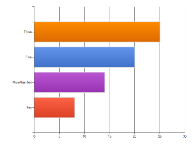
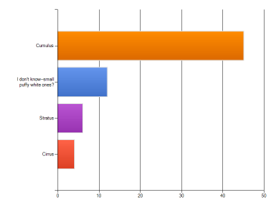
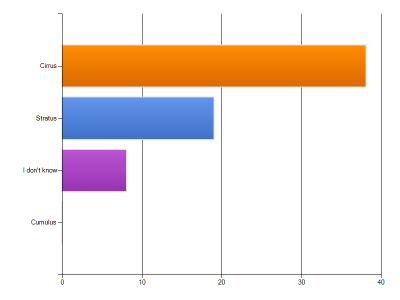
Question 1: How many basic types of clouds are there?
The answer I was looking for was
three: the three basic types are
stratus,
cumulus, and
cirrus. The names are based on Latin terms describing the cloud's general appearance: stratus=layer; cumulus=heap; cirrus=curl (as in wisp of hair).
The results were interesting for a variety of reasons. Though I inadvertantly included the names of the three cloud types in Question 6--and many people pointed this out to me--my gaff did not seem to overly influence the results. Only 37% of you answered "three." It seems that those of you who knew a little something about clouds (that is, that there are hundreds of types), might be the ones who answered that there are ten basic types: stratus, nimbostratus, stratocumulus, cumulus, cumolonimbus, altostratus, altocumulus, cirrus, cirrocumulus, cirrostratus. But, no one actually named all ten in Question 2, so I am thinking that ten was a good educated guess.
If you answered "more than ten," you get partial credit: there are hundreds of types of clouds, but they are not considered "basic." Each of the ten cloud types (genera) come in species and varieties (like plants and animals). So, there is a type of cloud called an altocumulus stratiformis perlucidus undulatus radiatus, though most people would call it "an altocumulus" if they called it anything at all.
The only totally wrong answer was "five." Those of you who said five were, admit it, just winging it.
QUESTION 2: How many of these cloud types can you name?
A whopping 30 respondents correctly named the three basic types--stratus, cumulus, and cirrus. Many named several types instead of or in addition to these--cumulonimbus being most often named. The most types named by one person was 9. Many people made up names, some quite amusing. Here is a sampling:
fluffy ones
long stringy ones
wispy and forboding
venticular
cumonubis
clouds that look like sharks
something starting with the letter N...
crap, okay, so I don't know many clouds....
Luckily, no one was being marked down for spelling: cumulous, cummoulous, cummulus. The correct spelling is cumulus.
Question 3. How often do you consciously look at or notice the clouds around you?
It warms my heart to know that I know no one who never looks at clouds. For those of you who answered "rarely"--I will let you know when you can pre-order my book.
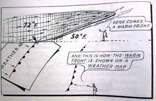
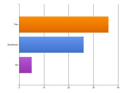
Question 4: Do you look at the clouds to help you predict the weather?
I am glad to know that the Weather Channel hasn't completely taken over our brains and connection to the living planet. In the few years I have been studying clouds and learning to identify them, I've also been trying to understand which clouds mean high pressure and which mean low pressure, which indicate a cold front and which a warm front. I've been looking to the clouds for clues to the weather 24 or 36 hours up ahead. I can predict rain now based on presence of cirrostratus clouds and a ring around the sun. Reading the clouds is a great skill to acquire, especially if you spend time in boats, on mountains, or trying to impress people at cocktail parties. But here in the Pacific Northwest, saying "I knew it was going to rain" doesn't really impress anyone.
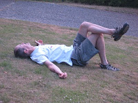
Question 5. Can you recall your first memory of watching clouds?
This question split respondents almost down the middle--half being able to recall their first memory, half not. The earliest memory was from age 3; the most common age for the first memory was 5. The most common memories were of looking for shapes in the clouds (hippos, ducks, princesses, sailboats, dragons, animals, umbrellas were named) and of watching a "thunderheads"(cumulonimbus) of an impending storm.
Nine described lying (sometimes laying) on their backs in their backyards, on their lawns, in hay fields, fields, or somewhere "outside" in the summer.
One person described lying outside and looking at the clouds to 'make them disappear.'
One respondent said they were disappointed in the clouds that didn't resemble anything.
One person recalls being on a road trip as a four year old and staring out the window watching the cloud after cloud after his/her father put a strip of duct tape down the middle of the back seat "as a demarcation line between my rival sibling and me."
My first memory was at the ripe age of 12, when I remember getting laughs for spotting clouds that looked like Richard Nixon in profile. This would have been 1972.
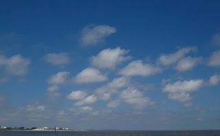
Question 6: What type of clouds are these?
The correct answer is cumulus. This is a type of cumulus cloud called cumulus humilis. These are low, puffy individual clouds composed of water droplets (instead of ice crystals) and are found at altitudes of 2,000-3,000 feet. The "humilis" part of its name means it has minimal vertical extent--a humble cloud. This type of cloud indicates fair weather, but can build into a cumulus mediocris, then a cumulus congestus, then the giant cumulonimbus under certain conditions.
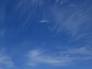
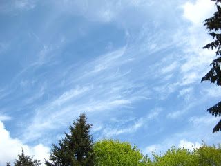
Question 7: What type of clouds are these?
Most respondents correctly identified these as cirrus clouds. They are the highest clouds, occuring at altitudes of 16,500-45,000 feet, and are composed of ice crystals (not water droplets). This type of cirrus are officially known as cirrus uncinus, which means the streaks are shaped like commas or hooks. When you see these clouds, watch for a deterioration in the weather. Often these cirrus will spread, thicken, lower, becoming altostratus clouds (a mid-level layer) and then nimbostratus (a low-level rain-bearing layer). Several of you chose "other" as your answer to this question and provided some nicknames for these clouds:
mare's tails [an accepted nickname]
the long stringy ones [hmmmm..]
long-haired democrats fleeing the party
chiropractors
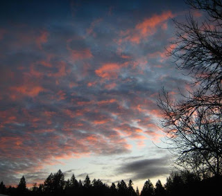
Question 8: Everyone loves pink clouds, but can you explain why they are pink?
About two-thirds of the respondents had a basic grasp of this phenomenon, using words such as "reflection," "refraction," "sun," in their answers. A subset of this group managed to include words such as "atmosphere," "angle of sun," "dust particles," "penetrate," and "wavelength." But because I included my large, extended family of liberal arts majors and my friends in this survey group, I suspect many of these responses do not actually reflect any real comprehension of the phenomenon.
Several (as in seven) respondents offered an explanation that indicated a comprehension of the phenomenon...and a willingness to put it down in writing. Before I offer the real explanation, I would like to share some of the less scientific explanations:
something with reflection and light and something i don't know
because everyone looks good in pink, even men...
sunset?
sailor's delight?
bending light into lower wavelengths
I always think of a newborn baby's blanket
they're embarrassed
a storm is coming
it has to do with the time of day
can't explain it, but feel like I have known
because the sky is on fire with my wittiness?
to make us feel nice at the end of the day?
rho scattering [this stumped me and ten pages of Google searches, then lead to a virus attack of my computer and much gnashing of teeth]
The short answer is: when the sun is low in the sky, the atmosphere scatters the short, blue-looking wavelengths of the sunlight and only the longer red- and orange-looking wavelengths penetrate the atmosphere and reach our eyes. The scattering is a combination of refraction (bending), reflection (bouncing), and diffraction (more bending) of the light waves.
The long answer, complete with helpful analogy for sports lovers. NOTE: This explanation took me half a day to compose, with much gnashing of teeth because I realized I didn't fully understand the phenomenon adequately to be able to explain it to ya'll:
The sunlight we see (visible radiation) includes light of differing wavelengths (imagine a rainbow or prism). From shortest to longest, the wavelengths appear as violet, indigo, blue, green, yellow, orange, and red.
When these wavelengths enter the Earth's atmosphere, they collide with microscopic particles of dust, salt, soot, mist, aerosols, water (sometimes in the form of clouds). The collisions cause the wavelengths to change direction, bounce, and bend repeatedly due to what some of you referred to as of reflection, refraction, and diffraction. Stay with me.
During the day, when the sun angle is high, the wavelengths have less of this obstacle-laden atmosphere to penetrate. Sportfans: Think of the Earth as a baseball, with the layer of atmosphere being the leather cover. Imagine poking a set of pins of varying lengths (representing the wavelengths) straight down through the leather cover--easy, right?
Now, in the early and late parts of the day, the sun's angle is lower and the wavelengths have to penetrate more of the atmosphere. This would be the equivalent of stabbing your pins nearly horizontally through the leather cover--not so easy, right? In fact, you are probably bleeding right now.
Let's substitute your pins for light rays and the leather cover for the atmosphere. For most of the day, the shortest wavelengths--the violet- and indigo-looking ones--are scattered (which is why the sky isn't purplish). The blue-looking wavelengths are short, but long enough to penetrate the atmosphere and reach our eyes without being scattered by the particles of dust, soot, moisture, etc. This is why the sky appears blue most of the time.
At sunrise and sunset, however, when the sun angle is low, the thicker layer of atmosphere scatters the blue-looking rays, too, so they do not reach our eyes. The longer, red-looking wavelengths (your really big pins) are not scattered and travel unimpeded to our eyes--giving us pink sunrises and sunsets.
In the photo above of the pink clouds, the atmosphere is clear enough for the blue wavelengths to still penetrate, but the extra moisture in the clouds scatters all but the red- orange-colored wavelengths. Voila! A beautiful, cloudy sunset.
I do hope this helped.
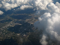
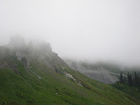
QUESTION 9: Have you ever experienced a cloud up-close--either by hiking to cloud-level in the mountains or at ground/sea level (fog)?
Only two respondents answered "no" to this question. All the rest of you had great stories to share about flying through clouds or hiking through stratus (fog), nimbostratus (low rain clouds), or some higher cumulus clouds. Close-up encounters took place in a variety of locations--surf casting in Monterey Bay, hiking in the Cascades, boating in Puget Sound, hunting in the Scottish Highlands, rowing on the Potomac River, walking to school in Port Angles, hiking in Glacier National Park, driving in Arkansas, standing atop the Empire State Building, hiking in Costa Rica and Anchorage and Huangshan "Yellow Mountain" in China.
My favorite answers:
"I was fascinated with being in a cloud...but disappointed when I found out that being in a cloud isn't anything like being in cotton candy or feathers or marshmallows or whatever else clouds look like."
"...we got very wet adn even though it wasn't raining, the fir trees were dripping water. It was like they were combing the moisture out of the cloud."
"My first memory of being in a cloud was in the winter in a meadow and we were snowmobiling and we all stopped and wondered at its magnificence adn then drove through it which was very exciting and probably pretty stupid!"
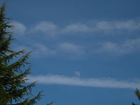
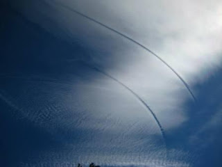
Question 10 Can you identify these types of clouds? Do you know how they are formed? (The round thing is a moon, not a cloud). 
Short Answer: This is a contrail, short for condensation trail.
Of the 67 respondents, 10 answered "contrails" or "jet trails; "
15 did not know or guess at the correct answer.
A smattering of respondents anwered "stratus," "cirrus," "cumulus," "altocumulus," "smog," "jet stream" (which is not the same as the stream of exhaust from a jet).
And....two smarty-pants identified the tree on the left as a Douglas-fir. It's a hemlock.
And one respondent, unable to leave the answer blank, decided to provide information on how the moon was formed ("when an asteroid slammed into the earth and slammed a chunk loose. at least that's one theory i've heard.")
For those interested in more....
Long Answer: A contrail is a long, narrow cloud produced by the exhaust of a jet engine. The engines emit hot, moist water vapor and particles of unburned fuel and soot. Most contrails form above 20,000 feet. Depending on the temperature and moisture in the surrounding air, the water vapor will condense in the cold air, form wataer droplets, then ice crystals, then a cloud. If the air is relatively warm and dry, the contrail will evaporate quickly; if the air is relatively cool and moist, the contrail may linger and grow in size. The contrails in my photo had been hanging out in the cool moist air and were expanding and being spread by the wind. These old contrails look different from straight and narrow newly formed contrails.
NOTE: I didn't Photoshop this...but thanks to the respondent for the back-handed compliment.
And because I just can't stop, below is a photo I took from my front yard of a distrail, short for dissipation trail. It's the inverse of a contrail. How these are formed will be discussed in an upcoming Cloud of the Week blog posting.