
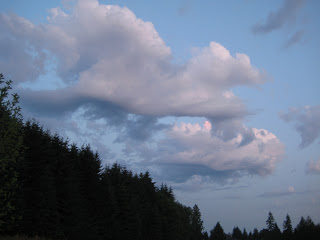
Am not sure what's going on here meteorologically, but this was the scene last night in Olympia at 9 p.m. before the Big Storm moved in. I have never seen this type of cloud formation before--a cumulus cloud with a windswept undulating underside, but I had a feeling it had something to do with the predicted rain. I had been watching and photographing the sky all day (from my hammock in the backyard and elsewhere) as altocumulus clouds moved in and covered about half the sky in large patches with cumulus congestus lurking on the horizons to the northwest and southeast. Oddly (or perhaps normally), the altocumulus cleared out around 5 p.m., then storm clouds began appearing everywhere.--the massive, billowing cumulonimbus clouds A cold front was moving in fast as if it was racing to get in place before sunset. I hopped in the car to get to my skyviewing spots before the storm hit. I caught the image above about 30 minutes after sunset. At this point in my research, I can only say that it must have been part of the front, perhaps what some books call a "gust front." I am trying to figure out exactly how they work.
Quite frankly, it is all quite overwhelming. I am still struggling with the basics of pressure and density. I need a live-in meteorologist. Maybe a webcam on top of my roof with a real-time narrative from an unemployed weatherman or weatherwoman willing to hang out on my roof in exchange for ummm, meals, acknowledgement in my book, and a signed copy of my book.
What book? Back to work.