
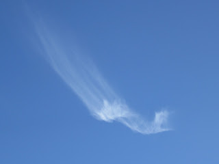
As promised, more on these unusual cirrus clouds I photographed a few weeks back and blogged about. I sent my photos to Art Rangno in Arizona for an explanation of the dramatic "tail" shifting (it did a 180-degree turn, from the 3 o'clock position to the 9 o'clock position as I watched it).
Art Rangno has spent most of his life studying and loving clouds, 30 years of it as a meteorologist with UW's Department of Atmospheric Sciences in Seattle. He is an accomplished scientist in the field of airborne cloud studies and is the creative genius, photographer, and writer of the popular "guide to the sky" cloud posters, which got me hooked on clouds in the first place. Speaking of hooks....
The cirrus clouds above are called cirrus uncinus (hooked cirrus) and here is what Art knows about them:
Cirrus uncinus usually, as we think of it, has a hook, but it can also be a tuft at the top as in your first photo [below].
This would have happened many minutes before your first photo, likely over the horizon and out of view, as indicated by the length of the fallstreifen, aka, ice crystals. At first, the formation of a cirrus uncinus is hard-looking, sharp edged dots and it has been suggested that they are water drops before almost instantly converting to ice (temperatures are generally below -30 C). There must be some updraft to do create those specs, somewhat like in cumulus, but much more gentle, perhaps of the order of just a mile or two per hour. One of the signs that there was an updraft with stronger and weaker portions is the stranding that shows different sizes of particles developed when the cloud formed. The different sizes are due to the differences in updraft velocities, the larger crystals forming where the updrafts were that bit stronger.
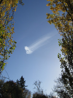
They are formed, from time to time, out of the blue as something that would resemble a patch of cirrocumulus, a granulated cloud patch [below], though usually the granules are more splotchy.
At the stage you have photographed this cloud, they are usually "done", at least in their updraft stage, and now the crystals are merely settling out from the original location, and as they do, you get to see how the wind changes with height, normally the crystals falling into regions of somewhat lower wind speeds below the "head" and leaving a comet's tail below.
The reason that they exist is that the air up there is likely saturated with respect to ice, or, below the head, very close to it. The longer and lower the tail goes, the deeper the near ice-saturation layer.The crystals in these clouds are almost always bullet rosettes [below], BTW, ones that can get pretty large, and hence, fall relatively fast compared to the smaller crystals in haze like ice clouds such as a high veil of cirrostratus.
 |
| Photo courtesy Cal Tech |